Viewings: 5495

The first mention of the flat stones with relief image of the Earth's surface dated back to XVII-XVIII centuries In the beginning of the last century, also wrote about the white stone slabs with reliefs and strange inscriptions. All these reports say the findings made in the same area of the Urals.
Professor Alexander Nikolayevich Chuvyrov from the Bashkir state University was engaged in the studies that have nothing to do with stone slabs. Since 1995, he and his Chinese graduate student Juan Hun tried to substantiate the theory of migration Chinese tribal groups in the Urals and Siberia. Scientists have really found a lot of facts confirming this hypothesis. Evidence of the hypothesis of migration may in particular be carved on the rocks in Bashkortostan ancient Chinese hieroglyphs. An analysis of the names of the rivers and mountains shows a large number of coincidences with the words of the Chinese language Jo-Kuen, disappeared from use 2.5 thousand years ago.
Sandanska stove
In search of materials on the subject, the researchers worked in the archives of General-Governor of Ufa, where they found the documents of XVIII century, which were discussed on the findings of the Russian expedition that found about 200 white stone slabs with reliefs and inscriptions. This message has interested scientists, and they decided to walk in the footsteps of the old expedition to find and examine at least some stone tables. In the beginning of XX century archaeologist Schmidt claim to have seen six white boards, but somehow not photographed and made them pictures.
The search proved more difficult than anticipated. Professor Chyuvyrov and his colleagues was thinking that the mentioned white boards do not exist in nature. As sometimes happens in life, helped case. In 1998 Chyuvyrov wanted plate some notes in the area. In 1999, the resident of the village of chandar this area Vladimir Krainev heard that scientists are searching for the white stone slabs, invited visitors to himself. Under the veranda of his wooden houses really laid a huge gap-toothed stone, very similar to those mentioned in older documents. The owner did not agree to give up the stove and yielded to the entreaties only when he promised to replace it with a new Foundation.
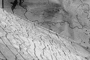
Heavy plate carefully dug a week, and when before the eyes of scientists appeared in all its surface, they were amazed. Before them was a three-dimensional relief map, rather, a map - stone bloc (1.48 x 1, 06 x 0.16 m) weighing not less than a ton. In addition, on a stone slab adorned inscription, which the researchers first took over the ancient Chinese text. Chyuvyrov could hardly believe my eyes - so incredible was the long-awaited opening...
The finding was taken to Ufa and investigated in the laboratory. After thorough cleaning of the stone card scientists begun to define the area presented to her. It was not so easy. Russian and Chinese cartographers did a thorough work on the comparison of stone with contemporary maps and managed to prove that it is a map of the Ural region.
The material from which made relief map, consists of three different layers. The Foundation is a slab of concrete dolomite thickness of about 14 see the Second layer in the thickness of 1-2 cm was very interesting: specialists determined that it diopside, type of cement. It is using it and created the relief in stone. How the treated surface of the plate, is unclear. Experts unanimously say that manually create the terrain is impossible - such amazing accuracy not be achieved using a cutter and chisel. Diopside applied in dolomite in a way that is not currently used and science unknown. Superficial white layer is coated of a thickness of approximately 2 mm It is made of porcelain and protects relief from external influences.
Research conducted in China, found that the composition of the porcelain on the stove different from Chinese. There are supplements that Chinese never used.
Russian scientists tried to decipher the inscription on the gravestone, but they failed, and their Chinese colleagues Chumikova of the University is not able to read ancient signs, only found out that on the surface of the plate - hieroglyphic syllabic writing.
On the stone map scientists discovered many unusual. Along with a designated river channels on closer examination you see artificial hydraulic engineering structures, in particular the two channels, a system of dams and large reservoir. The canal system was designed to accumulate and pass huge masses of water. Compared to this construction, the Volga-don canal seems hardly visible line on the map.
With the definition of the stone age card too, encountered unexpected difficulties. First Professor Chyuvyrov and his colleagues have determined that the white table about three thousand years, but then they never had such confidence. The fact that different techniques of definition of Dating gave quite dissimilar results. On the surface of the stone disseminated two sinks. One of them, navikopsina munitus, about 500 million years, and the second eccuiiomphalus princeps is about 120 million years. This age card theoretically could also be adopted as one of the hypotheses, although the presence of shells not necessarily directly related to the time of making maps.
In our time, three-dimensional maps are for navigation purposes. For their manufacturing are necessary for aerial survey, including space. To make a three-dimensional model of a mountain, requires the resources of the most powerful computer. In the USA there is work to create three-dimensional maps of the Earth, which should be completed in 2010 And to found a stone slab made detailed terrain in scale of 1 : 1,1 km, caused Belaya river, Ufimka and Bustle.
If we assume that the white plate precise relief maps of all areas of the Earth, the plates should not be 200 and 384. Scientists believe that these fragments exist, and they can be found. Probably, separate fragments were huge map that is cracked and fell to pieces during the ice age.
Russian scientists sent the results of their research in various scientific institutions around the world, that colleagues had an opportunity to compare them with existing materials. But one card that resembles a failed copy white table from Bashkortostan, never has anything like this. Relief stone plate conditionally called "card Creator"because absolutely no idea who created it, how and with what purpose and who then used.
Ufologists around the world hardly doubt that the map was created by a highly developed civilization, which had the technical possibilities for its production. Skeptics can always say that rich fantasy capable of any relief to turn into a geographical map. The estimated card is so ancient that since its creation the surface of the Earth has changed a lot. But Professor A.N. Chyuvyrov believes that "the changes aren't global", and therefore the district of Ufa hills is easy to learn. The southern part of the plateau has not practically changed, and on the other side was a huge canyon from Ufa to Sterlitamak, along the bottom of which flowed a wide and deep river. This canyon is now not likely, on its place there is the river Urshak. The most shocking signs of reasonable activity. Professor Chyuvyrov believes that the modern society is able to fulfill more than one millionth part of what is depicted on the map. But what is the most powerful civilization could create such a grandiose creation? While the answer to this question is no one knows...


