|
Viewings: 9315
 The starting point in the hypothesis of the Rand Flem-ATA became all the same assumption about the mismatch Plato geographical terminology current notation. This assumption has unleashed the researcher hands, and he did a little experiment. Off his usual school globe with axis and began to turn him away to the North. He stopped the globe in the moment before his eyes appeared Antarctica, i.e. in the centre of the world as would be the South pole. Having examined carefully opened on the globe picture, Rand of Flem-ATA made a number of interesting conclusions of direct relevance to the problem of Atlantis. The starting point in the hypothesis of the Rand Flem-ATA became all the same assumption about the mismatch Plato geographical terminology current notation. This assumption has unleashed the researcher hands, and he did a little experiment. Off his usual school globe with axis and began to turn him away to the North. He stopped the globe in the moment before his eyes appeared Antarctica, i.e. in the centre of the world as would be the South pole. Having examined carefully opened on the globe picture, Rand of Flem-ATA made a number of interesting conclusions of direct relevance to the problem of Atlantis.The researcher took the original of Plato and re-read a very interesting place: "(that is, from the island of Atlantis) was easy to move to other Islands, and from there - on the whole opposite mainland, which frames the TRUE ocean. Because the sea on this side of the Strait of Gibraltar is only a Bay with a narrow passage in it". Rand of Flem-ATA could not discourage the use of Plato's words "Bay" in relation to the Mediterranean sea. Only one thing could serve as his excuse: so great was for Plato "true ocean"that Mediterranean sea seemed to be compared with him a small harbour! Hardly on the role of "true ocean" could pretendentsky the ocean, because it is known to practically isolated from other oceans of the Earth's continents. But when you look at "world" over the South pole of the Atlantic, Pacific and Indian oceans merge together, and maybe they form that the "true ocean" Plato? Yes and continents bordering with this view "true ocean", is much more expressive than Atlantica! Readers must have already guessed what was coming Rand of Flem-ATA: it places the legendary Atlantis ... Antarctica! Such an option, it seems, no one has yet proposed. And interestingly, the researcher finds new arguments in favor of his amazing assumptions. Plato says that Atlantis through the territory was more than "Libya and Asia together". Under Libya philosopher meant North Africa, and Asia believed areas that we call the Middle East. Libya and Asia "taken together", according to Flam-ATA, slightly exceed the size of the current United States. Approximately the same ratio of the size of Antarctica (somewhat reduced due to the later formation) and the United States. Next Plato adds that Atlantis was a mountainous island and stood "high above sea level". And in this respect the analogy of Antarctica full (it rises to almost 2000 metres above sea level). In 1665 German Jesuit the physics engraving the Kircher has released the multipage document, including a reproduction of ancient Egypt map of Atlantis. Comparing the configuration of the island with the outline of Antarctica, as it was 12,000 years ago, shows how considers Flem-At, their striking similarity. Although Egyptian map Atlantis placed in the Atlantic ocean, flem-At considers this an error, which allegedly fell and Plato. Traditionally it was considered that Antarctica is covered by ice for at least 50 to 60 million years. But in 1990 250 miles from the South pole geologists have found frozen in ice remains wood forest age of 2 to 3 million years! The famous map of the Turkish Admiral Piri Reis, founded in 1513 based on older maps Dating back to !V century BC, depicted Antarctica without ice! On the map of Orontius of Phineus prepared in 1531, see mountain ranges and rivers in Antarctica where now only the glaciers. All this shows Maslennikova Antarctica in the memory of mankind, which in those times incomprehensible way, not having aviation and the more satellites were able to draw up maps of the southern continent with outlines, applied only in the XX century by the methods of seismic sounding of the sea ice cover! Cartographer Charles Hapgood found that map Piri Flight contains at least 24 points, adjusted with an accuracy of half a degree. Europeans could not reach such accuracy to the famous voyages of captain cook in the second half of X\/III century! Hapgood many years developing unrecognized by official science the idea of periodic shifts of the earth's crust (lithosphere), "floating" more viscous layer (asthenosphere), based on a solid mantle (thick layer between the earth's crust and the core of the Earth). And along with the bark "travel" pools and oceans! This idea enthusiastically took albert Einstein and even wrote the Preface to the first edition of the book Hapgood "Displacement of the earth's crust". Hypothesis Hapgood has a direct poles remain in place, and under them simply changing panorama. By the analysis of climatic changes due to the displacement of the earth's crust, the author comes to the conclusion about the past warm climate in Antarctica. And this circumstance he gets his "Antarctic" version of the location of Atlantis. Finally, Hapgood refers to the Japanese Emperor ancient times the Darker, which in 681 ad ordered my Guild chroniclers to gather the old myths of the Country of the rising sun. In the end, there was a book of myths and one attitude to the problem of Atlantis, for the displacements of the earth's crust due to sharp climatic changes on the planet without having to admit "rocking" earth's axis, that is, "walk" the poles. Actually, Hapgood of them referred to the times when the Earth was "very young" and the first inhabited the country was called "Negorozhina". And it was situated... not far from the pole. Hapgood convinced: near the South pole!
You are reading news Атлантида парадоксальная версия
if You liked the article Атлантида парадоксальная версия,
prokomentiruet her.
|

The world of the unknown - Onua.org
Onua.org - this site created to familiarize the user with the world of the unknown, news of technology, space discoveries and mysteries of the Earth UFO, Video , Photo, the Witnesses, the mysteries of history and ancient civilizations.


Menu
- Anomalies
- Hypothesis
- The Mysteries Of History
- Unknown
- News
- Opening
- Top secret
- Prophets
- Ancient civilizations
- Egypt
- Rome
- Greece
- Anunaki
- Nazca
- Maya
- Cosmos
- Technology
- Flora and Fauna
- Atlantis
- Bermuda triangle
- Aliens and UFOs
- Cloning
- Loch Ness
- Mysticism and Magic
- Time machine
- Parallel world
- The Tunguska meteorite
- Third Reich
- Teleportation
- Snow man
- 2012
- Nibiru
- Solar system
- The sun
- Earth
- Mars
- The rest of the planet
- Photo
- Video
- A little about everything
- Украинские аномалии
- 2013-2014 YEAR
- Questions and answers
- 100 great
Interesting
Recent VIDEOS
News calendar
Join
Popular Onua.org
Photo
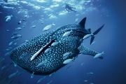
The biggest fish in the world - not blue whale as one might think, because the whale belongs to a ma
Before it was invented fridge, its functions were performed in the ice, which was considered a preci


Предлагаем восстановить, заказать, купить диплом Вуза в любом городе России. Только настоящий бланк ГОЗНАК с гарантией.
All rights reserved