Viewings: 5752
Has already become a celebrity, covered with legends Arkaim; known in the scientific world and which gave the name of archeological culture of Sintashta; less famous, but already studied the Mouth; covered with fame on the results of the last excavations, Quick and ?land - all South-Ural Country cities. Scientific naming of this clot fortified settlements of the XVIII-XVI centuries BC - monuments protocity civilization of the bronze age in the southern Urals. Country towns - the name for the shared use, it is best meeting the core of the Chelyabinsk phenomenon. Was already in the middle ages Gardarika, and all understood that this is a Country of cities - Rus.
Were there any country of the cities of the same age and similar Chelyabinsk? Surely were. Not from space as they descended to the South Urals at the time of the Egyptian pyramids. And after a half century (rounded up), not in space he was gone." And they came to us and left on the ground. Find the remains of fortified cities, such Arkaim and its neighbors, thousands of miles away, mostly younger. For example, the imaginative title Arkaim - "grandpa Troy" - it's because he's older sung by Homer castle in Asia Minor for many many centuries. The city, or rather protogoroda bronze age are, but to a country ' almost four thousand years old... yet. And can, and will never find such. Millennium civilization than once or twice he ruined the past to the ground, so that "new world to build an"as a famous hymn. It is possible, without a trace erased other "country of Archakov". Our just very lucky. Only a century and a half ago there appeared a rare village. To plow, sow uninterruptedly, building and roads everywhere began only in the last decade - from the virgin lands. And not all our Country cities survived, and hail in one piece, like Arkaim,while no one will call.
The country's cities has a clearly delineated boundaries. In the North - Th, in the West by the Ural mountains, in the South, in the border of the Chelyabinsk and Orenburg regions, in the East approximately along the Meridian of Troitsk, - the border with Kazakhstan. Perhaps, on the East border will move. Country cities has "height" (along the Eastern slopes of the Ural mountains), about 400 km and width" (to the East from the Ural river) 120-150 km map "country" inflicted 17 points cities, but there are already more than twenty villages of intestinal tens. Each castle was the center of the neighborhood, like a rural area, with many, like modern villages.
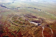
"The city" surprisingly similar. Be sure it is surrounded by walls and moats (by the way, is quite complex fortifications). In the plan it is oval, circle or rectangle, close to the square. Oval" six cities: Bertaut, ?land, Isina, Cornel... the same round, Arkaim is one of them. Most "angular": steppe, Mouth, Springs... There are those in the plan which outlines of the fortifications are superimposed on each other. For example, on aerial photographs of the Steppe and of Kousaka Shine through all three figures. Here three times rebuilt the fortifications. It is considered, at first it was built on the oval, then round, and at sunset the Countries - cities rectangle.
Whatever form the castle, it was built like a typical project. In the centre of the required size. One or two streets paved with round logs, under them livnevka, here discharges of domestic sewage. In houses (it is, rather, apartments, walls General, a kind of one-storey house for 10-30 "apartments") - wells, cellars, kitchen with pockets and a "party", a bedroom. "Apartments" huge - up to a dozen bedrooms-rooms. The total area of each "apartments" 100-180 sq.m. apparently, they were generic, bedrooms on the number of families, but only by 60-70 kin. If every "apartment" historic and workshop. Sculpted utensils, weave and sew clothes. Was stolarnia and collected battle chariots (the oldest in the world). There were a lot of metalheads - bronzeware, Kuznetsov and founders. Cattle citizens are not kept. The city was the centre of the rural districts in several villages, where bred cattle, sowed grasses. Found traces of irrigation.
Today, the most widely believed that "the city ' were spiritual centers, lived here and do the rituals of the priests gathered here at the sacred festival tribesmen from across districts. The square in the center of the city was their temple under open sky. The fortress were garrisons of soldiers of the tribe, under their protection tribe had taken refuge during the attacks of enemies. Cities were manufacturing plants. Craftsmen lived under the protection is not accidental: their ability valued, especially by the creators of metal and tools made of it. There is an opinion that the Country's cities originated here because of the affordable and good-quality copper ores. And fortresses were set up to protect the mines and metallurgical "factories". Next door to the famous now acted Magnitogorsk bronze age. Local metal and guns went on export" far beyond Yuzhnoural.
Particularly impressive metallurgical "shop" Sintashta. The city-fortress was reconstructed and expanded, were transferred walls and a moat. The inner fell almost exclusively wastes of metallurgical production. Here are found almost all that pertains to him today. This allowed archaeologists not only imagine how melted bronze our countrymen, but to reconstruct ancient foundry and even smelt bronze on their technology. The process of bronzeware was not easy.
About one and a half centuries flourished in Yuzhnoural Country cities. Then intestine left. Their place is not left empty, it won apparently related tribes. But nothing like that here never was. Different opinions about who these were intestine, why and where they have gone a lot. No wonder! The discovery and research of Arkaim and the Country's cities by no means ordinary. "Should be considered as a scientific event of epoch-making procedure" - says authoritative expert on the ancient settlements of Eurasia I.t.kruglikova. To add to his opinion nothing.
More than fifteen years have passed since then, as was opened the first in the Country cities hail Sintashta. However, that is a whole country", guessed later, when opened Arkaim and started desifrovat aerial images. Since then, each year brings new discoveries or on the excavation, or in the office lull in the study of the materials from the excavations. Open a new grad Linnet, opened a huge lake Peipsi mine "thieves pit"... Exceptionally rich material excavations gave the place on Alannah.
Arkaim
Arkaim - archeological complex, including fortified settlement and adjoining economic platforms, a burial ground, a number of unwalled villages. The name "Arkaim" (perhaps from the Turkic (bash.) rch" "range", "back", "basis") is given the name of hills and hollows. The complex is situated in the Chelyabinsk region, on the river B. the Bolshaya, and its left tributary of the river Utyaganka, in the foothill valley on the Eastern slopes of the Ural mountains. The monument dates back to the 2nd quarter of the 2nd Millennium BC (17-16 centuries BC).
Radiocarbon dates - 3600-3900 years ago. The complex is investigated from 1987 archaeological expedition of Chelyabinsk University under the guidance Gbesemete.
The total area of 20000 m2. The area of the archaeological site (1993) - 8055 m2. Geophysical studies carried out on the square 7600 m2. The settlement is recorded in the form of two inscribed into each other, rings earthworks with 4 aisles external ditch, two circles housing depressions and Central area (Fig.1). Shafts are the remnants of defensive walls, made of soil, mud-brick blocks and wood. Diameter of internal walls (walls of the citadel) - 85 m, 143-145 m, the thickness of the walls at the base is from 3 to 5 m, the height of the ground part in ancient times was not less than 3-3,5 m To the fortification structures include radial walls that broke the outer ring of dwellings for 5 or 7 sectors. Dwelling in terms of trapezoidal, terrestrial, 110-180 m2, constructed out of wooden frames and ground units.
Adjacent dwellings had total length of the wall. About 1/3 of the area of the dwelling set aside for General use. Here are a well, a cellar, a hearth, combined with iron stove. Home citadel facing outputs to the Central square. The area had a rectangular form (h m) and was intended, obviously, for ritual actions. Home of the outer ring is facing exits to the circular street that connected all the entrances to the village and all dwellings with Central square.
Under cover of circular street detected ditch storm sewer with waste water wells. On the settlement archaeological excavations investigated 29 dwellings: 17 in the external and 12 in the inner circle. Geophysical methods established that only in the outer circle were 35 houses in the inner - 25 (19 - big and 6 small, built between the main dwellings in the process of growth of the population). Collected 9 thousand fragments of ceramics, articles of bone and stone, gun metal (knives with interception, sickles-Struga, awls, decoration), many things connected with metallurgy and Metalworking: molds, slag, nozzle, hammers and anvils. The richness of the cultural layer of the material remains small. The farm population of Arkaim was based on herding cattle with elements of agriculture. 96% paleontologicheskij findings are the bones of domestic animals: 60-65% - cattle, 20-25% - small cattle, 15% - horses. On the territory of the Arkaim valley within 5-6 km from the fortified center recorded at least 5 multilayer bronze age settlement with the remains of layers 17-16 centuries BC, it was Probably small settlements without fortifications. It is not excluded that with reinforced centre were connected and more remote unfortified settlement.
General plan of the settlement of Arkaim.
The burial ground of Arkaim is located on a lion. shore R. Braganca, in 1-1,5 km North-East of the settlement of Arkaim Investigated 5 mounds. Dominant position in the burial ground is occupied by large, with a diameter of 17-19 m, burial field, uniting 12-20 pits. The peculiarity of the burial architecture determine deep up to 3.5 m - burial pit with a vast hollow burial chambers and terraces, several wooden beams. From the top of the pit were blocked by individual subsoil bulk designs, or monovoltine domes of Adobe blocks. Burial in the pits single, pair, group; tropopause on the side, slightly or srednesrochnoi position. The anthropological type of the buried - proeuropeans. Burial accompanied by a rich inventory, especially in Central pits: bronze leaf-shaped knives, axes-Tesla, chisels, awls, harpoon, spearhead, other products made of bronze arrowheads, stone and bone, stone Mace, accessories, horse harness, decorations, etc. In ceramic complexes dominate ostranenie pots decorated with geometric designs. Numerous remains of sacrificial animals (horse, cattle and small cattle, dog). Also studied were the burial field, uniting on 7-8 burial pits with relatively poor burial items.
Cultural complex of Arkaim is in the group of fortified settlements of the southern Urals, named "Country of towns". It is located South of the UI, is primarily the watershed of the rivers Ural, and Tobol. "The country of towns" consists of two dozen complexes. The length of the occupied territory 350-400 km in the direction of North-South and 120-150 km in the South-East. The distance between existed simultaneously fortified settlements amounted to 50-70 km Radius developed area corresponded to 25-35 km Cultural complexes Arkaim (intestinalnogo) type with their hierarchy of settlements and burial grounds is useful to consider how the territorial education with elements of early statehood.
Arkaim - superoperator ancient Aryans?
Arkaim was discovered in the summer of 1987, already in 1991 the territory of the monument was declared a nature reserve (in the status of a branch of the Ilmensky reserve). Like it or look - yesterday sensation; however, the interest in it has not weakened. Moreover, it certainly extends followed by archaeologists, historians, ethnographers in Arkaim reached psychics, prophets, pilgrims, members of the various religious sects, people thirsting for healing and enlightenment, - in a word, everyone personally see This Place...
Already featured articles - strictly scientific and scientific-popular, filmed the movie (though France); reports about the Arkaim scientists are serious and representative conferences.
We all have witnessed a rare miracle! And not in some exotic Micronesia, not among biblical stones in the Middle East, not in full of mysteries South American Selva, and downright house near by, in the Chelyabinsk region was opened "Country of towns" - the balance of one of the oldest civilizations of the humanity: the original, no matter what accustomed is not like structure, with powerful walls complex of the defensive constructions, melting furnaces, craft workshops, a clear system of communication... Now recognized: here is the homeland of the ancient Aryans, which scientists have been looking for on a vast territory from the Danube steppes to the Irtysh; here occurred on the verge of III - II millennia BC have "computed" linguists division Aryans into two branches - the Indo-Iranian and Iranian... And some of the so restrained in the scientists ' assumptions ready even to declare these places the birthplace of Zoroaster, the founder of the sacred hymns "Avesta", as legendary as the Buddha or Mohammed.
The phenomenon of Arkaim made the historians change ideas about the bronze age on the territory of Ural-Kazakhstan steppes. Now it appeared that they were not to be the backyard of the world, who entered the era of civilization: the high level of development of metallurgy provided this region is very prominent place in the cultural space, stretching from the Mediterranean to present Kazakhstan and Central Asia. And some of the same type metal objects wonderful candle, found it somewhere on the coast of the Aegean sea, in the southern Urals and indicate the length of cultural ties, as it turns out, wandered through caravan routes not "from there to here", as always considered, and "there"... Obviously, needless to prove, that the correct representation about the direction of these flows is important not only to meet local Patriotic ambitions. The opening of this level are really rare - maybe once in a century.
Can it be assumed that such discoveries are never accidental that the time works for them - as if waiting accumulate in people for granted deadline. How else to explain the fact of the phenomenon and the salvation of Arkaim? After all, it is perfectly visible on aerial photographs taken much earlier years of opening. Then it was suggested that the views of experts as would have diverted itself is excellent preservation of the most ancient monument: it seemed that such a strict geometric forms should have a purely modern origin. What? In our sverhsekretnoj the country to ask such personal questions was somehow not accepted.
Miraculously appears and the salvation of Arkaim - case of this kind is hardly anywhere else noted in the entire Soviet history. Because the monument was doomed - so about it and told the media. He found himself in the flooded area of the constructed reservoir. Was already built a retaining dam; it remained only to fall asleep short the jumper and spring waters would not have left from Arkaim clue. Followed by months, if not weeks, and it seemed that no force in the world, which can stop a heavy flywheel "planned economy"...
A miracle, however, was man-made. Many still remember as rose in defense "Ural Troy" (comparison, as it turned out, rather flattering for Troy, scientists, journalists, intellectuals. The struggle for the salvation of Arkaim coincided with the crusade of the public against the social-bureaucratic arbitrariness of the Soviet system, the system was breathing hard - it helped. The idea still fell, but Arkaim left...
In the book "Arkaim. The research. The quest. Opening" collected rich enough information about the monument, as he opened the archaeologists, who centuries-old layers of the soil, and about the collected during excavation of the objects of material culture, and about the surrounding ancient sites of ancient settlement (a lot of them in Arkaim valley - prochorenko "the Country of towns"), and physical-geographical conditions of the strictly protected zone, and about the uniqueness of the local vegetation (also, incidentally, a subject worthy of a surprise), and even about the history and life lived in the district Cossacks. However, the closer listen to the texts of the articles collected here, the more one can feel the breath yet undiscovered mysteries, the more I realize that not only sparse information that leaked through the layers of thousands of years, due to a certain aura of mystery that surrounds the ancient settlement in the South Ural steppe.
This is what, for example, writes about the Arkaim doctor of geographical Sciences Evevev: "Is a town-fortress, the city-workshop foundry, where was made of bronze, this city-temple and Observatory, where perhaps there was sophisticated for its time astronomical observations. The latter requires more hard evidence and justifications".
About the Observatory is not speculative assumption. During the two field seasons (1990 and 1991) on the Arkaim conducted the survey astroarchaeology Konstantin Konstantinovich Bystrushkin. Partially they fit into the overall plan of archaeological work is allowed to clarify some details of documents in the field of excavation and partly answered orientation own scientific interests of the researcher.
Preliminary results of observations and measurements were summarized and presented at the highly respected meetings of experts: on the astronomical seminar at Pulkovo Observatory in Leningrad branch of the Institute of history of science and technology, the Institute of theoretical astronomy, astronomic and geodesic society, and also in Institute of a name of P. K. Sternberg in Moscow and Sverdlovsk Observatory. In all cases, the results of the work of K. K. Bystrushkin astronomers accepted with great interest and assessed very positively.
And what are the main results? Before you say about it, will lead the words of a scientist, to whom belongs the honor of discovery of the monument - archaeologist Gennady B. Zdanovich: "... I imagine Arkaim as the brightest example of syncretism primitive, blend and verschiedenste various started. It is both a fortress and a temple, and craft center, and a settlement". Now, K. K. Bystrushkin does not contest this certification, but adds to it one more important detail: the Arkaim, in his opinion, among other things, also prioriteta Observatory limit of accuracy class, the most difficult of all currently known to mankind. In this respect, it is comparable with Stonehenge - famous megalithic construction on Salisbury plain in southern England, which is still in the middle of the XVIII century was guessed ancient Observatory; however, this conjecture has been quite convincing arguments and wide recognition only two hundred years later. But only Arkaim was harder Stonehenge... And another detail: archaeologists estimate the age of the Arkaim in 3800-3600 years; Cry, based on the technique, increases it for a thousand years.
The highest monument of culture with age 4800 years. Four thousand eight hundred years...
Design
The excavation of Arkaim did not find jewelry masterpieces of the treesit art, a unknown writing, nuclear reactor or spaceship. Only fragments of broken pottery, bones of domestic and wild animals, rare stone tools and very rare bronze. But even these ordinary things on Arkaim very little. Collection "artifacts" so poor and dull that it cannot do prelestnuyu the occasion of the Museum exposition.
Now, eight years after opening, it is clear that the main value disturbed ruins was and will remain the DESIGN of the structure.
The study plan designs found in it a complex and precise geometry.
Measurements on the Arkaim was subjected to the so-called mainland relief - what can be considered the Foundation of the entire structure. However, foundations - in the strict meaning of this word is not there at all: the design was kept on a pole piers and cabins. However, such construction technology involves "zero cycle", then there excavation of the pit for premises and the formation of ridges as the basis of future walls. These wall-edge and measured because they create the whole picture of plan of constructions and is the most visible and striking result of the excavations in kind. Wall foundations typically involve a series of posts in the excavation they presented a pole holes. To imagine the site in General, these ridges and pits should be added to the pits and wells in the middle part existed here once premises and ditches along the perimeter of large parts plant. That's all. Other elements huge structures were almost completely destroyed first by the fire, then water, winds, by the time...
Of course, the topography of the continent gives only a distant view of the whole construction. Construction was developed in height, had a solid walls and ceiling, galleries, bridges, add-ins, second floor and high wooden tower. Reconstruction of parts of the volume has already started, and, presumably, its results will be interesting and impressive...
In fact, archaeologists already have quite a full idea of what was the settlement in the valley of Arkaim in times of its prosperity, and the results are really impressive. First of all it is necessary to emphasize that this large building was not a conglomerate of disparate objects, and solid design. The plan looks like this: two inserted one into another ring powerful defensive walls (external circled by a ditch by depth of 1.5-2.5 m), two ring street dwellings, crouching inside these walls, and at the geometric center of the rings - the site in the form of slightly flattened circle diameter 25-27 metres, carefully leveled, compacted and maybe even fortified some cementitious mortar. Diameter external walls - about 150 meters in thickness at the base of 4-5 metres. Erected she was from a timber mill scored soil with addition of lime, and skinned raw blocks, starting from the bottom of the pit, and to the upper edge - a total of 5-6 meters. The inner wall was surrounded, apparently, the citadel - with a diameter of about 85 meters. The thickness of the wall was smaller - 3-4 meters, and height, probably more than the exterior. Was it strictly vertical and out - timbered facing - clayed.
Ring dwellings were divided into sectors radial walls - in the sense they are like spokes of a wheel. These walls were common for every two adjacent rooms. Add to this rather complex and elaborate interior layout dwellings and annular street, cunning trap to destroy the intruders to the connector on the external defensive wall and other fortifications, rational system of storm sewage; even the colors used by ancient arakzai facing materials were functionally and aesthetically significant.
Now even on the basis of such a miser verbal sketch - you can judge how orderly, reasonable organised life of the community of people flowed once inside these walls.
However, the apparent complexity of social organization of people who has built up thousands of years ago is a miracle of engineering art, is not all that detects the opinion of the expert, contemplating today the outlines of the ancient protogoroda: the geometry of the building is fraught with riddles.
Why is a circle? Is this something to do with the symbolic nature of the thinking of ancient? If so, what does this symbolism, who and why addressed concluded in her message? That's what, in particular, the Association has caused the plan of Arkaim his pervostroiteley, B. Zdanovich and I. M. Batanina: "This layout is similar to the principle of the Mandala is one of the main sacred symbols of Buddhist philosophy. The word "mandala" means "range", "the disk", "pie". In the "rig Veda", where it first occurs, the word has many meanings: "wheel", "the ring", "the country", space", "society", meeting"...
Universal interpretation of the Mandala as a model of the Universe, "maps of the cosmos", while the universe is modelled and is depicted in the plan with round, square or their combinations. Arkaim and his dwelling, where the wall of a house wall is another likely reflect the "circle of time", in which each unit is determined by the previous and determines the next".
In "the Country of towns" affects not wealth of material culture - affects its amazing spirituality. This is a special world where spirituality full of everything - from settlement and burial architecture to sculptures made of stone"...
It is deployed study K. K. Bystrushkin.
The topography of the continent finds bright, accurate and complex geometry. There is no doubt that here we deal with the results of the preliminary design, which was made by the builders in nature. Cannot be and speeches about what Arkaim was built in several stages, as necessary, when it is already finished parts are attached a new quarters. No, it was built again, and it is clear that the project was preceded by careful design studies in terms of hydrogeology and engineering properties of soils. Undoubtedly, in advance have calculated the volume of earthworks and necessary for the construction of wood (thousand of barrels of coniferous and deciduous trees!).
Arkaim - the construction is not just difficult, but even a sophisticated complex. Meanwhile, the purpose and functions it is not at all obvious. And only when his plan is detected precise geometry, there is hope literally to calculate the plan of builders. The search direction is suggested unexpectedly exact match some important elements of the geometry and dimensions of Arkaim with the appropriate parameters of Stonehenge. All archaeological publications about the Arkaim nazyvaet diameter circular walls of the citadel of Arkaim - 85 meters. But it is slightly curved. If it be measured with the precision required for astronomical observations, it is not perfectly correct ring with a radius of 40 and 43.2 meters. Meanwhile, the radius of the ring "Aubrey holes" Stonehenge also 43,2 meters. Both monuments are located almost on the same latitude, both in the middle of the bowl-shaped valley with relief horizon. And that's not all: the more closely match both monuments, the more it is found in them the exact details.
The mapping between Stonehenge and Arkaim may seem surprising: after all, they are separated by the length of the whole of Europe, 4 thousand kilometers - long distance and current means of communication. And a lot of the time interval: if we accept the traditional view, that lies between them for a Millennium.
Geography nothing can be done, but the chronology is another matter. In the end, its accuracy depends on method of research.
In the famous book by j. Hawkins and J.. White "Stonehenge decodedge "first stage" of the monument of Stonehenge-I, as the researchers say, is defined in 4 thousand years (or more precisely, its creation is attributed to the XIX century BC plus or minus 100 years). But this is not the only opinion.
When using the classical methods of archaeology - on the basis of analogies - Stonehenge is a bit younger than people themselves are the authors of these books: "On some of Sarsenovich stones Atkinson found a total of thirty images bronze axes and one image, apparently, dagger in its sheath type that was used in Mykonos town, exactly in the age established a preliminary estimate, in 1600-1500 BC" is Published, its age today about 3500-3600 years?
Richard Atkinson is the main among English archaeologists connoisseur of Stonehenge; it long and persistently resisted attempts to apply to the explanation of the mysteries of the monument methods of astronomy, but in the end became an ardent enthusiast of astroarchaeology. Well, Sarsenova stones are megaliths, framing ring "palisade" Central construction of Stonehenge.
The same, by the way, the method was defined and age Sintashta - "the findings discoid psali Mycenaean type, copper spears with defective Bush, stone stemmed arrowheads, paste warty beads and other things". The same method and the same result: the XV - XVII century BC And the age of Arkaim this traditional method is estimated at 37-38 centuries.
Required clarification: Sintashta is the name of the monument, located on the banks of the same river, relatively close of Arkaim. It was opened one and a half decades earlier, and in two steps at once, and a decade later - studied thoroughly. However, first, it has survived much worse than Arkaim; secondly, it is quite noticeable out from the system known at the time of archeological monuments of the southern Urals, and it is meantI was not clear. Opening of Arkaim had served as a stimulus for joining many separate and even mysterious facts in some convincing chain, the academic community includes the concept sintetisko-Arkaim culture. Archaeological findings made in Sintashta, are now being used as standards for the selection of this culture, and its center is recognized as "the Country of towns".
Application of methods of radioactive analysis "aged" Stonehenge for a thousand years. Now "Aubrey holes"related to the stage "Stonehenge-I" (those, the radius of the ring is equal to 43.2 m), dated XXVIII century BC
On the arch and its associated monuments radiocarbon analysis did not less than three times, using dozens of samples. In most cases, it turns out that Arkaim - the same age as Stonehenge or even older than him.
Finally, there is another method, named after its inventor - English astronomer Joseph Norman Lokier, but it can be applied only in the case if the case is about the age of the ancient Observatory.
The idea Lokier was, in essence, is simple. Based on the study design of the Observatory is determined laid down in its terms of direction on the main astronomical event that there once was observed. Due to the circular motion of the planets and stars in the Universe this direction over the past century has shifted, but now it's not hard to determine with the help of modern observation equipment. By measuring the angle between the old (recorded in the eternal material) and current trends, specialist without special efforts will calculate divided their time interval. That's all. The difficulty was simply to believe: we really Observatory (and not some defensive building or temple). But just to believe it was difficult: first, sophisticated astronomical knowledge did not blend with the image "primitive" primitive; secondly, it was not clear (in truth, it is not clear now), why were ancient people such perfect knowledge about the movement of the heavenly bodies. And Lakieru did not believe: in 1966 solid journal "Antiquity" published an article "Moonlight fantasy on the theme of Stonehenge", against astroarchaeology interpretations of the monument and sustained, as can be seen even by title, condescending-ironic tone. But the accumulation of facts became increasingly difficult with them not be considered...
At the turn of the last and present centuries, Lockyer first astroarchaeology used my method for Dating the number of monuments, including Stonehenge. The result confirmed the opinion of the archaeologists who used traditional methods: say, a monument created about 3,600 years ago. However, it later emerged that he had been wrong determine the azimuth of the main directions of Stonehenge 20 minutes, and that "aged" monument more than a thousand years.
Assuming in Arkaim also the ancient Observatory and by using the method of Lokier, we found that Yuzhnouralskaya monument for the same age as Stonehenge.
Synchronicity of these two monuments means a lot. Including that of the Mycenaean analogies have a very different direction than is widely believed: the subject of the civilized items not migrated from "cultural" Greece in the "wild" Siberia, but just the opposite. Does it mean that in the design of the both structures should search for a common basis, and not dismiss matches, believing them random.
Here, of course, there is one problem: the stone monoliths of Stonehenge passed through millennia practically without losses (however, one of the zealous "restorers"guided by taste, "patronal"still somewhere chain of stones, savagely distorting their astronomically strictly verified geometry)and wooden construction elements Yuzhnouralskaya protogoroda almost completely lost. They don't even have rotten - they died in a fire that raged here for almost five thousand years ago.
The fire that put an end to "live" history of Arkaim, is one of the most intriguing mysteries of this monument. It would not be anything special if it was one of those natural disasters, which is not so rare even in our day overnight destroy entire communities, castiga as any trouble, residents by surprise, burying the Smoking embers decades belongings, Pets and even the masters themselves, unable to break free from the prison-fire. The singularity of Arkaim a fire that he apparently was not a surprise for the residents of the settlement; it is likely that they in him and burned. Because only this can explain the fact that in the ancient ashes there are no suitable for everyday things: the so - fragments, fragments. Much of the human remains and there is no speech is all gone live, all securities with a claimed. Why? One of the plausible versions suggested by Professor I. Century Ivanov: say, 3500 years ago there was a huge explosion of the volcano of Santorini (on the territory of modern Greece), which caused an ecological catastrophe. In large parts of the planet, established the weather is similar to that projected in the occurrence of "nuclear winter". Apparently, this was accompanied by some natural anomalies, which were accepted by the inhabitants of Arkaim as a sign and forced them to leave the town, false to his burning. Well, this version is good - for want of a better. However, in order to recognize it sufficiently convincing, it is necessary, first, to determine exactly what 3.5 thousand years ago Arkaim still existed (archeoastronomical studies K. To Bystrushkin give reason to doubt); secondly, to know something more or less valid concerning the beliefs of the ancient arkhiptsev. However, there remains a fact: built at once, by a single plan, proto-city of Arkaim overnight and ceased to exist, abandoned by their inhabitants and, probably, they also burned.
...But neither fire, nor the time could not destroy the Arkaim "mainland relief", remained the same and also the line of the horizon, remote from the monument to the distance of one and a half kilometers from the West to five in the East. And on the horizon discovered at least 38 objects that traditional archaeological classification are certified often as "anthropogenic object of unknown purpose", and for specialist astroarchaeology and archeogeology it is quite evident that we deal with here is a sight that were used by the ancient observers of light.
Summing up all these facts, you can make unmistakable conclusion: an ancient prioriteta Observatory.
Prioriteta Observatory
The word "Observatory", of course, known to all: so nazyvaet scientific institution, located in the building of special design and are equipped with special tools for systematic observations is astronomical, meteorological, magnetic and seismic.
The ancient world knew Observatory special kind - such now do not build. Their name day astronomical, or prioritetnye, observatories of the Sun and the full moon. They were not equipped complex devices, which then did not exist, but they nevertheless were made very accurate observation; high accuracy was the distinctive feature of this type of buildings.
How were they built? Will try to briefly explain "physics of the process".
The horizon is the only place in the sky where the Sun can be observed unprotected eye. Moreover, the Sun is near the horizon, you can look into the lens of a theodolite without a filter. In the years of active Sun is near the horizon visible spots on the Sun, they can be considered, to observe their movement on the disk and see the angle of the axis of a rotating star. And all this can be observed with the naked eye.
The horizon is a special place in the field of human rights: towards him look undergoing a distortion of linear perspective. Our perception as though increases all the items that are close to the horizon and those on the horizon, the moon and the Sun appear near the horizon greater than in the higher points of the firmament, and the reason is not optical effects caused by the state of the atmosphere (the effects of these features, but they are quite different - for example, by flattening and shake the bottom edge of the light), and the causes psycho-physiological. Simply put, the special structure of the human brain. Aristotle knew about it. And this truth perfectly proved instrumental measurements. Figure horizon from nature is very much otlichalis from pictures: picture more visible and more details. This property of human perception dictates special conditions archeoastronomical observations: it is necessary to work not with photography, or, say, video, and be sure "on location" - and as he worked ancient colleagues.
Procedure sunrise (and call) daytime running lights lasts in our latitudes of about 4.5 minutes and takes in a quiet, even the horizon about one degree of its arc. Important moments of observation, the appearance of the first beam, that is the highest point of the solar disk, and the gap completely rising drive from the horizon. Not easy to decide which of these two points is preferred by ancient astronomers. Theoretically not simple, and almost preference bottom edge, who tried to do, no doubt. (The more obvious preference of this point when it comes observations of the lunar disk.)
If strictly with one and the same place to watch sunrises and sunsets, reaching the lower edge of the disk (let's call the moment they separate disk from the horizon or the touch of his "event"), it is easy to find that every morning and every evening event takes place at different points of the horizon. During the year dot event moves over the horizon, first to one, then in the opposite direction, but within the same sector. OnChav observations in the spring, in March, we will see that the Sun rises exactly in the East, but day by LTOs point events all over peremeshaem left, that is, to the North, and quickly: every morning for almost the diameter of the disk. To verify this, you need to put on the horizon landmarks, marking the place of event.
Point to move the event to the North will take place during the spring, but the daily variations will gradually decrease and by the beginning of the calendar of summer, in June, will reach a barely noticeable value of one minute of arc. In the period close to 22 June, daily motion events will be reduced to half a minute of arc, after which the motion of a point events will go in the opposite direction. This point is called the summer solstice; the word is now in progress, and yet it came in everyday language from the practice prioritetnoe astronomy.
Point to move the event to the South lasts all summer, and daily variations his uvelichivaet by September again to the size of the disk. And after passing the time of the autumnal equinox (September 21; at this time, the point of the event is exactly in the East) turn again slowed down until you stop altogether at the beginning of winter, December 21: come winter solstice. Hence the motion again will go to the North and by the spring reaches a point East... So was and always will be.
Strict repetition of this process was seen by ancient astronomers and taken, that is, by the armed forces. The point of the summer (in the northeast) and winter (in the Southeast) solstice, due to their strict locking, had particularly great practical importance. First of all - for precise orientation in space. In the language of the ancient Greeks were even geographic terms, meaning directions for the summer sunrise and winter sunrise.
The importance of extreme points of events is determined by the need for accurate calendar. In fact, observing the events on the horizon is the only real and accessible DL ancient astronomers way to determine the duration of the year. Even for vedeni calendar with daily accuracy they needed prioritetnye Observatory, giving the opportunity to record with a limit to the naked eye accuracy astronomically significant events.
The number of clearly fixed astronomically significant events related to the observation of the Sun, just a little bit - there are only four: two extreme of the year points solar sunrise and two - calling. Only four points on the entire flow of time length in the whole year. In the rhythm of life itself and others were some significant milestones. For example, the point of the equinoxes: in practical life they were probably even more appreciable, than point solstices, for fixed start and end of biologically productive season in Northern Eurasia.
Therefore, the attention of the ancient astronomers naturally attracted and another heavenly body.
Moon digits in the sky (from the point of view of the observer) faster Sun twelve times. But the movement is more difficult. "The hunt for the Moon" - perhaps the most interesting and exciting in the history of astronomy. To understand the procedure and natural beauty in its daily sunrise and visits very difficult - its movement, the unenlightened view, fitfully and unpredictable. However, in prioritetnyh observatories since time immemorial were able to unravel the hare loop lady of the night.
The first step that should do is to recognize that the most convenient for observing lunar event phase of the full moon. Second: among full moons you should choose only those that follow immediately after the significant events of the Sun, - it is necessary to correlate in a single stream real-time two calendar is lunar and solar. The most difficult problem moon observation is that the onset of the full moon rarely coincides with the appearance of light on the horizon: this is usually done when she either had not yet risen or is already quite high in the sky. To fix the point moonrise directly in the line of the horizon is the direct supervision is usually impossible, DL finding razrabatyvayut various indirect methods. Suppose, however, that we have already learned how to do it. Then a long-term observation (one event per month, and meaningful to four times a year) will allow you to discover the laws of peremeshano lunar events on the horizon. And these laws.
First: the full moon coming up over time by the time of the summer solstice, observed near point winter solastuan and Vice versa. This "reverse" can be regarded as a basic rule in the relations between the sun and the Moon in our sky.
Second law: the events of the moon migrate from year to year nearby relevant ("oborotnej") points of the Sun in the narrow sector. The migration cycle - about 19 years. When an event occurs in the extreme Northern point of the sector, then the astronomers say high" moon; when it is moved to the extreme southern point - say low" moon. The time interval from low to high the moon - more than 9 years.
When set boundaries and rules of motion of the points of the moon, observers can start "aerobatics" in technology prioritetnoe astronomy. Masterly technique and accuracy combined with pedantic diligence requires the observation of precession.
Dictionaries define precession (as astronomical concepts) as the slow movement of the earth's axis by the circular cone. (A similar motion makes the axis of the gyroscope or - the most obvious for the uninitiated example - axis launched the child's spinning top. Therefore, the term "precession" is used not only in astronomy.) The axis of the cone normal to the plane of earth's orbit, and the angle between the axis and forming a cone equal to 23 degrees 27 minutes. Because of the precession of the vernal equinox point moves along the Ecliptic towards the apparent annual path of the Sun, passing 50,27 seconds per year; the pole moves between stars and Equatorial coordinates of stars vary continuously. Theoretically displacement should be 1.21 degrees for five thousand years, that is less than one and a half minutes for 100 years. Thus, over forty years of continuous and meticulous observations (whether a longer period of observations within one human life?) dedicated to his job astronomer can detect the precession just a minute! At the same time will show the firmness of points and sectors of the equinoxes.
The reader, far from the astronomical worries probably little that I will say these degrees, minutes, seconds, expressed, especially in numbers with decimal fractions. They hardly ever come in useful at the device of their practical Affairs, and the author here they won't need to justify any conclusions. But, I think, they are still worth noting here at least, to show how subtle observation, ingenuity, skill, diligence, ability to spatial imagination and to massive generalizations it was necessary to possess the ancient astronomers to take full advantage of the opportunities prioritetnoe Observatory.
Will add, not resorting to additional argument that throughout the year such astronomer was given (the mechanics celestial bodies) 18 astronomically and calendar of significant events (you can say it differently: strictly fixed points of reference, to which he could make other observations) - nine sunrises and nine visits. In each of the nine three events otnosatsa to the Sun and six - to the moon (three - to high" and three low"). This is "periodic table" or, better, astronomical "ABC", which, by the way, each event has its symbolic. But we don't have to come here so far.