Viewings: 9800

About 2000 years ago, one of poorly known South American civilizations created these mysterious image. In the vastness of the Peruvian desert Nazca these lines, drawn by Red rocks wilderness, represent more than 100 known plants and animals, simple geometrical figures, as well as a scattering incomprehensible, not related to each other straight lines. There are many theories explaining their meaning and answering the question why they were drawn, but their true purpose still remained a real riddle.
The world's largest piece of graphic art covers the area and 520 km2 in Peru. A quick mention of the Nasca lines occurs in Spanish researchers XV-XVII centuries, but mostly, they remained unknown to the outside world until the 20-ies of our century. But they did not become the object of serious research, while in Nazca by 1941 went American archaeologist Dr. Paul Cosquer from the University of long island.
Later, German mathematician and astronomer Dr. Maria Reiche has dedicated 40 years systematization and description of these shapes and attempts to explain their meaning. All figures in the desert is performed by one and the same way: the surface layer of reddish rock continuous line scratched until the underlying pale yellow rock. Apparently, this was done manually.
Topics drawings can be divided into two categories; it shapes and lines, the latter either paired as tramways, or form geometric shapes, And because in many places they are drawn on top of an image, it is obvious that first were made drawings. This image leaves and branches of various plants, figures of animals and birds and strange creatures, such as a person with a head owls and birds with incredibly long, like a snake, neck. The line is so direct that there is an assumption that their conduct was used staves, which fits "eye". Even so, there still remains a mystery, how has the drawers so just stick to the plan and achieve the effect of a flat line at such large distances.
Date back to the Nazca lines period between 500 BC and 500 ad; it's possible that it works Nazca Indians who inhabited the areas of Peru before the formation of the Inca Empire. Nazca were farmers and farmed the fertile plains along the Pacific coast of Peru. They have not left posterity is no evidence of the existence of writing at them: all known facts about them was obtained through the study of burials Nazca and found them items. So fragmentary information about the culture of the Nazca Indians do not explain why they are so persistent painted desert.
According to one version, the lines were ancient highways that it is unlikely, since many of them are suddenly cut off tops of hills. The most popular hypothesis was proposed by Dr. Field Coscom, who believed that all these figures and lines are "largest astronomical book of the world". His view is shared by Dr. Maria Reiche. She suggested that these pictures showed the stars and constellations in different seasons were used by ancient Nazca to determine the exact time of plowing, sowing and other important "stages" agricultural cycle. Beaks shows some birds, for example, indicate natochka sunrise and the day of the solstice. The fact that the lines can clearly be seen only from the air, caused the emergence of the theory that in the time of their creation Nazca Indians seemed to be able to fly or, at least, to brood over the earth. But although this fantastic idea not so incredible - pottery are drawings, depicting a cross between a kite and a balloon, - it does not explain why Indians Nazca these figures and lines.
Modern scientific studies from the University of Massachusetts seems to reveal a secret of their meaning. The research team, which includes the user Stephen B. AMA and archaeologist Donald Proulx, said that some of the mysterious lines can actually point to underground sources of water. The team also includes an independent Scientist David Johnson, who is from the Department of anthropology at UMASS, and graduate students Jenny discovered and Gregory Smith. Ancient inhabitants of the Nazca might have noticed the location of their distribution system supplies of ground water, because during droughts, they were more reliable sources of drinking and irrigation water than the river.
Spatial coincidence between the lines and ground waters, offers an intriguing explanation of the function of some of the lines. Scientists noticed long ago that the region of the symbols of animals, plants and people, and performed on the pottery Nazca almost identical. As they would represent the deity of natural forces - heaven, earth and water, they needed and which "calmed" these pictures to get a lot of water and a good harvest. The team studied the drawings and schemes of underground waters for three separate trips to Peru, in the past five years. The study was funded by the University of Massachusetts and the National Geographic Society.
So far, the research results indicate that the underground water table has provided a source of reliable and uninterrupted water supply to residents of Nazca. This water, in comparison with the river water is the best quality when comparing the levels of pH, magnesium, calcium, chloride, and sulphates. Was performed archaeological and geological survey of more than 128 locations drainage systems. Their discovery provided the approach to the solution of different puzzles and lots of archaeological finds were found near the occurrence of submarine groundwater rivers that were used Nazca as an important secondary source of water.
Thanks aviation in the XX century were found painted on the surface of the earth mysterious pictures of huge sizes. The most famous today are the drawings in the Nazca desert (Peru). The mystique of these drawings is incomprehensibility of their appointment, in ignorance of the people that created them, as well as the method of application to the surface of the earth. These drawings can be seen only from an aircraft or from a great height. Sandy plain of Nazca length of 60 km is located 400 km South from the Peruvian capital Lima.
In these places the land for years't see moisture. Raindrops sometimes, falling on a hot rocky surface, immediately evaporate. This lifeless space is the perfect place for a device here burial, ensuring the undying. Tombs were arranged in dry stone formations, over which the top was made drawings for the formation of the vertical flow of energy (space communication channel). Here at sites occupied by the figures, scientists and archaeologists-lovers have found more than 200 thousand of ceramic vessels. It is not excluded that a hollow vessel, buried here on the earth's surface, was steering the flow of energy and a counterpart of that vessel, which was laid to the grave of the deceased and served as “the home of the soul”. Ceramic vessels had different designs and stylized drawing of the image, and on one of the vessels was even white-penguin. Large areas of ancient mummified burials in the pyramids, hills and other structures, a lot, but with picturesque images found until three. This is Nazca, the West lake. Titicaca and at the source p. Apurimac. The latter areas are poorly understood, as they are in the mountain areas, where there were major religious centers of antiquity. Their study may give you new interesting findings.
The official science believes that these signs shall bear one of the native American cultures to Inca period “Nazca”that existed in the South of Peru 1100 - 1700 years ago. Here on the plateau there is a network of shallow flooding of underground passages (irrigation system), and a network of deep tunnels that run under the pictures with tombs. It is known that in ancient times on all continents for the tombs were arranged vertical energy flows in the form of pyramids and ziggurats, mounds, chapels, labyrinths, etc. Sometimes used the energy flows of the temples, burying people in them, or near them, natural energy flows over the tops of the mountains, arranging crypt below their peaks. Since ancient times the vertical energy flows were created through the labyrinth of drawings with the rollers, using the energy of the natural radiation zone. Such figures were consecrated, and temples.
Unobtrusive, Labirinto-pictures have never been ruined by earthquakes and conquerors. The groove with the rollers have an increased flow of energy from the earth's surface in comparison with smooth surface. The flow of energy (air, fluid) above figures-labyrinths, coming from the earth, visible in the hot weather as haze. This flow of energy moving upwards and on the ground in certain areas, regardless of the direction of the wind. These near-surface energy flows have a strong vitality. About these energy flows modern specialists know, but the ancient priests not only knew, but used them in religious purposes when creating ground and underground objects, including the tomb.
Flows near-surface layers of energy priests could artificially to concentrate, to reject them in the right direction, including through grooves-rollers. The larger size picture and more total length of furrows, the more the surface of the earth is going near-surface energy that is directed to the place of formation of the vertical flow of energy. This JVwas substvalue and curvilinear zigzag lines of the figure. You can expect the most important person was in the tomb, the large size should be the figure and the total length of lines. The choice of the form of the figure, probably due to the additional name - nickname which he wears when life even modern leaders Indians (eagle, Monkey...). In addition to name these people are feathers, fur and fangs animals etc. Given that large pyramids and other religious buildings usually accompanied system of underground passages, we can assume that the system of underground passages should be in the area of drawings of the Nazca desert.
Existing studies provide an opportunity for the quick penetration into the system of dungeons, as known in these places other underground irrigation system moves-tunnels, which somehow write a little. District pustyni Nazca drawings and underground tunnels (Koltsovo I.E.) Deep burial-vaults and underground passages had entrances, freight and ventilation wells. As a rule, in these underground systems were and underground churches. This temple must be inside the neighboring mountains, which can store ancient written materials and answers to many questions, including in the part of creating the mysterious drawings. The underground system of tunnels with various tombs, temples and other cavities is the original town-Museum (the city of the dead), it stores of knowledge, culture and the spirit of the past. Researcher drawings “Nazca” Maria Reiche argues that the creators of the first drawings were doing some sketches, and then play them in the right larger sizes. As evidence Maria Reiche shows little sketches, detected in the area. In addition, at the ends of the lines that form the figures were found wooden piles driven into the ground, which played the role of coordinate points in the drawing. It is established that piles belong to the VI century ad To the same period are the remains of settlements “Nazca”discovered not far from the mysterious drawings. For contemporary specialists - architects, constructors-aviationshow, Rozmetov and other professionals - is not difficult to apply to the surface figures large in size from the small drawing-sketch. For this, they too would coordinate points with the use of piles.
Such jewelry work they do professionally, daily, with millimeter accuracy. It is well known that large mysterious drawings on earth are also in the USA (Ohio), in England, on the Ustyurt plateau (Kazakhstan), southern Ural, Altai, in Africa (to the South of the lake. Viktoriya), in Ethiopia, etc. it turns Out that in ancient times, the application of large pictures on the earth's surface was practiced in many parts of the world. Type and form of drawings were different everywhere. Drawings are not intended for public viewing. Invisible from the earth signs provided safety of the tombs from plunder. Surely the priests were on the small plates plan all areas with pictures and dungeons, at which the priests could determine the location of the underground technical and cult constructions, designated entrances to the underground. To see pictures and signs of the Nazca desert is possible in our time with the nearby mountains at certain times of the year and hours. Here the ancient people to come at a certain time as well as our contemporaries go to the cemetery to our deceased loved ones, to communicate with their souls and spirits of ancestors.
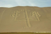
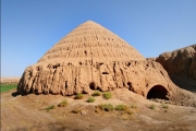
Nazca - exciting mystery disappeared Lemuria. This ancient Baikonur-map of the Earth indicates giant Trident, carved on the rock near the town of Paracas on the Pacific coast. Baikonur-map is difficult to capture mentally - 13,000 lines runways. 700 geometric shapes created by 520 square kilometers in Peru between the Andes and the Pacific ocean. German astronomer and mathematician Maria Reich forty years researched this plateau and realized that his lines symbolize the constellations, and the figures of the animals - the position of the planets. The area of the Andes with a magnificent dead cities and roads, built race-minded planetary scale. If she was making the spaceport, he became at the same time navigation and astronomical map of the Earth, which can be seen from other planets. This map is recorded in the equidistant projection all major megaliths Africa, Australia and the continent of Lemuria, from which there are now only miserable island. Excavations near the Nazca lines discovered pyramid! Multilevel pyramid 20-meter height stands on the hill, top of which is cut, and the foot surrounded by a wall of mud bricks. Around the pyramid several buildings and sites, the biggest one - 45 to 75 meters. The architecture of this complex repeats astronomical city Andes. At several points Nazca the compass rose “go crazy”.
The pilots saw here kilometers guidelines, giving precise direction to the cardinal. On the edge of the plateau traces of a powerful flood. Some days photographing figures from the air did not give results film after the developer had filmed over. Erich von d?niken believes that the Nazca could serve as a refueling interplanetary ships, because it fixed output unknown energies, when exposed film and compass needle “going crazy”. Next to this plateau discovered the amazing stone IKI crystal skull symmetrically with drilled holes in them that says that in the distant epoch here was doing complex operations on neurosurgery and craniotomy. Ancient surgeons Andes were able to replace damaged parts of the skull plates of gold. Not far from this plateau in the Western Cordillera found another amazing phenomenon - two of the maze, which helix twisted in different directions. Surprisingly, in these labyrinths of five to once a year descends cosmic ray of light duration of 20 minutes.
Those lucky people who got into the beam of the light, was permanently cured of incurable diseases, and women suffering from infertility, then successfully became pregnant. Who sends this light? Different civilization or worlds are on the Earth in the different frequencies of time and space? Perhaps plateau was and phanerotoma, and the spaceport for different aircraft. Landing strip is mild, rocky ground deserts washed away. Triangles informed aircraft about possible side wind, and squares on the best place of landing. The figures of the birds could mean the Parking areas. Near them there are large boulders, in form and weight convenient for mooring gliders and aircraft.
There are drawings of birds without heads and beaks, but with long curved neck. It reminds deployed before glider cable or rope. Representatives pratsivilizatsii flew across the Earth and on other planets, as reported to be found on Mars and the moon megaliths. Near California, near the city of Blind discovered a huge figure of a man, like drawings of England, and the shape of the animal and snakes in the form of a spiral. Most likely, these gigantic figure, as the spaceport Nazca, were by navigation signs for astronauts and pilots pratsivilizatsii.


