|
Viewings: 15011
 Shortly before the First World war on the occult yeast "Golden dawn" and theosophy in Germany creates magical brotherhood of Germanenorden. In 1918, it is divided to separate the Masonic brotherhood - the Thule Society. Its symbol was the swastika with a sword and a wreath. Shortly before the First World war on the occult yeast "Golden dawn" and theosophy in Germany creates magical brotherhood of Germanenorden. In 1918, it is divided to separate the Masonic brotherhood - the Thule Society. Its symbol was the swastika with a sword and a wreath.In the book by L. J. Pauwels and Bergier "the dawn of magic" tells the legendary story of Tula, related to the initial period of occurrence of Germanism. According to this legend, in the Far North once existed island Tula, disappeared, as Atlantis. This island, in the opinion of the members of the Thule Society, was magical center of a lost civilization. The members of the society aimed to raise the secret knowledge, making them his instrument in the struggle for power. However, where is this land, which was called differently in different times:Tula, Hyperborea, ARCTOGAIA, Arctida, Atlantis...opinions began to diverge even in ancient times, when in the IV century BC PYTHEAS from Massilia went far and the first such Platanias Gades(Spain), rounded Britain, reached the Northern coast of Scotland, where, and achieved the mystical island Tula..daleiden North sea reached the mouth of the Elbe and Jutland. However, in Herodotus in his "the history of the world", there is a certain navigational, dark "sea behind Slavs, on which the city of Tula". The idea of extreme inhabited island Tula in the North came to the Arabs of the ancient tradition, because in addition to the realistic tradition about Ultima Thule, considering it as existing in reality far North island, there was also idealizes tradition, creating a fabulous, romantic image of the distant Islands. The first written mention in the Arabian sources Ibn Horadada, it seems, has the same basis as described Atlantic; however, there is an assumption, not confirmed, that the name Tula in this case named Toulon (Velihanova. C. 91-Tr and 268-approx. ). At the same time, some researchers believed that "the sea behind Slavs" named Baltika (Lewicki T. Baltik w opisach autorow arabskich IX-X w. // Przeglad Orientalistysсzny. Wroclaw, 1949. Zesz. I. S. 56). Further, in the year 825, in Ireland, scientists monk Tequila was written the book "On measured and Earth", where among other things, the island Tula identified with Iceland. But PYTHEAS says that Tula - the earth is inhabited, while Iceland in his era was deserted. Distant island in the North believed Orkney Islands, Greenland, Shetland Islands, Scandinavia (which until the XII century was named the island), the Faroe Islands and, finally, one of the cans Faroe underwater hills, stretching to the Faeroe Islands Iceland, first of the former largest inhabited island. None of these hypotheses are not fully proven. And the name Tula - in the form of Ultima Thule, i.e. "Ultima Thule" - has become a symbol of the Northern "end of the world". About Taliansko land of talk and many representatives of Earth Sciences, and not only historians geographical discoveries. Volcanic island can not only be born of the ocean, but destroyed them. It is possible that ancient mariners not only opened up the island, the now extinct (which originated in medieval maps "legendary Islands of the Atlantic"), but also witnessed their death: for example, the famous map of Admiral Piri Flight there is an inscription that says that between Iceland and Greenland in 1456 "burned island"... From the foregoing it follows that the island Tula could not be higher than Segodnyashnyaya Greenland, i.e. in no case was not within the Arctic circle, but look at the map... In ancient times were compiled on the basis of the even more ancient absolutely amazing card. Approximately 1515-1570, these cards were not. But in the middle of the century, all at once, in different kartografu have an amazing card. They were released by a Turkish Admiral Perinasal, Bukmekerskom, great cartographer Mercator, cartographer Finem. These cards have reached us. And in this century they do. About 50 years a very serious scientists, geographers, cartographers are trying to analyze them with the help of modern technology. What is this card? They amazing? These cards are amazing on many points. They depict in the South Antarctica, and in the North - Arctida. Right at the North Pole represented the whole continent, and painted in great detail. Turkish Admiral Pirireis in the Preface to the set of maps writes that in this book there should be nothing that was not based on facts. It's such a claim to be scientific and reliability. He immediately warns here to never thought that deal with bullshit. Why is he so confident? The fact that there, in the Preface, he writes about Columbus. Opens a mystery how Columbus discovered America. Pirireis knew that Columbus had the same book as he does. Book of this, maybe about three thousand years. There were cards, which depicts North America and South America. Columbus knew where you are going, why, and why. The book was and description of the peoples who lived in America: what they like, what they there, and what we have. Namely, they fully gems, gold; and prekoputa wild peoples on the stack - lannie beads and cheap jewelry. Let us recall the history, Columbus came and changed with the locals glass trinkets of gold. As they got him? He did not know where she was going. He knew, everything I read in this rare book. It should be noted that these books were instances of five over the world. This, of course, a jewel. Pirireis on the basis of this book was his cards. On our charts Antarctica shown under a two-kilometer layer of ice, and on maps of Pirireis Antarctica without ice! Moreover, on the map were drawn mountain ranges, rivers and other details that were open only in the XX century. Using satellites, aerial surveys revealed that under the ice there and mountains, and rivers, as on the maps of Pirireis. Imagine the surprise of scientists! Where they knew? Card, and on it the mainland without ice. Maybe in Antarctica and in Arctica ice also recently formed? And scientists tell us, one that ice formed 200 million years ago, and since then it does not melt; others claim that at least 15 million years ago; others give a million, " who in his own way. And I write a lot of papers, theses, books on this subject, and the view - no. Let's think. If these cards, where Antarctica and Arctida depicted without ice and, moreover, as a flourishing region, were long ago somewhere someone made up, and came to us only in the middle of the century, the obvious conclusion. If the cards were drawn up for a very long time, and, indeed, may be, ice, too, lies a long time. But the cards may not be a million years. Agree? By no means can be. And the manner of their image suggests that they were created 3-4 thousand years ago. Moreover, modern scientists come to the conclusion that maybe the Arctic and Antarctic, in fact, from time to time, the last Millennium, free of ice. I will give these speculations. In the 60-ies of the Mercator maps, Tinea, Pirireis lot Professor Habgood from American University. By the time flew the first satellites and got the first pictures. Now, he come to a surprising discovery. He compared the structure maps and Antarctic regions and the Arctic with these photos. The mapping is spherical image distortion of distances, footnotes, very difficult to calculate relative distance. You use the higher mathematics to all exactly what to do. Now, he compared and came to the conclusion that the cards of Pirireis were made from aerial photography, from a height of about 8 thousand kilometers. What more can be said about the cards, especially on the card of Finea, 1535 Card Bookmakers, Mercator, Tinea show that the North pole ring surrounded by a vast continent, which is divided into four parts mighty rivers. Bookmakers, Mercator rivers flow from the Pole, Tinea, on the contrary, to the Pole. But the North pole on all three cards depicted as a rock, surrounded by the inland sea. So there is no doubt, under the figure inscribed in Latin "black Mountain and the highest". Apparently, this was the mount Meru, the axis of which our Earth rotates. The fact that there is inconsistency in the cards, is proof that not everything is so simple. Moreover, Tinea mainland Arctida depicted as a rather smooth four-petalled Lotus. Four petals, four Islands, separated by small rivers. As shown inside the small sea, in the center of which a huge mountain. The southern border of the continent is very close to the New Earth, for the Novosibirsk Islands, very close to America. What I want to say. It should be noted that different cartographers, from different countries, about the same card. However, where did the mysterious continent in the Arctic? What a fantasy moved your hand respected cartographers of the XVI century, making him draw in the Northern ocean, the ocean semisuite Big dipper what is not. And as such myth-making combined with an unusually accurate for the time the designation is not only European banks, but Greenland, the New Earth. The significance of these cards, their reliability, scientific factionist is that many of the ranges, Straits, bays and many other details are depicted with such precision that have been confirmed only in the XX century with the aid of aerial photography. Once in the XVI century were established such a definition image outlines Northern Canada, Hudson Bay of Islands The new Earth, then Arctida there! Interesting yet such research. Hossa, the famous historian of the last century, studied maps of Eratosthenes, it is about 200 BC, rather, the copies from them. They contained errors, which had its own system. The error said that the map of Eratosthenes was traced back to more ancient originals, the center of the projection which was in Babylon. But there is another important thing. Based on astronomical observations, which formed the basis of these cards, he calculated the estimated date of their creation - 3600 BC. It is about 6 thousand years ago. Notice, scientific facts that at least 6 thousand years ago Arctida and Antarctica were not hidden ice. So was the thaw. This is a serious evidence, not just reasoning and not to understand where and by whom planted card. Himself Feeney reasoned, "How could that be, in any case, not later than 6 thousand years ago, when the ice sheet covered the continent". Modern researchers in one voice say that was the ice and all proves that six thousand years ago it was not. In addition, the map was not the Bering Strait. With such accuracy map, and there are no Bering Strait? Remember, NICHOLAS Roerich often conducted such an idea, the idea of the Eurasian plan. All the inhabited continents one people, one humanity. American Indians is a degenerate Mongols Asia. And how did they get there? Very simply, was dry bridge Bering Strait was not, and it Mongols could take place in North and South America. Connection of all continents - that is binding thought. And when Atlantis was, dry bridge connects Europe and Africa with America. In ancient times to move from one continent to another was very easy, and you can barely wet feet. Here on the Islands through Atlantis, and there - from Asia to America on the dry isthmus. So warm was most recently, maybe even after immersion of Poseidonis (Atlantis) in the ocean. This is the period of last 10 thousand years was so. Interesting conclusion French scientist, a glaciologist. The main glaciologist polar expeditions many times in the Arctic and studied the state of glaciers. He came to interesting scientific conclusion that glaciation began about 9-10 thousand years ago, and before that in the Arctic was warm. Scientists, almost everything correctly determine the layering of ice per year. But even with all the bugs, it is about 9 thousand years ago. Consequently, the Arctic was without ice, that is, it was warm. This is very important! In 1935, the USSR Academy of Sciences found two towns in the valley of the Ob river, above the Arctic Circle. Many articles of animal style, the elements of the Scythian culture. Excavations clearly say that about 5-12 thousand years ago there was a rich vegetation and deep forests. This is the data of our scientists. And they conclude that heat was, they cannot be dated close, from 5-12 thousand years ago. But, mind you, not millions of years. Very interesting data on this subject there Abbot Bal. This Frenchman, a friend of Voltaire. At the time he wrote the book "Letters about Platonov-Atlantida", which leads me interesting reasoning. What are they interesting? It is known that Voltaire spoke with Great Teacher count Saint - Germain. Saint-Germain for a long time he lived in Paris, and Voltaire was with him almost friendly. And many important about the future, about the prophecy, Voltaire learned from count Saint-Germain. And Bal communicated with Voltaire, and probably it something is also supposed to get interesting, mysterious information. Bal says: "the first of Climate was much warmer than now, and the island of Atlantis was located in the Arctic ocean, somewhere in the region of modern Spitsbergen. When cooling has started. Atlanta left him and landed on the mainland in the mouth of the river Ob". Read the question immediately arises: could know Voltaire or Bal anything about the existence of the Siberian river Ob? It is unlikely that they could have something to say, even to think about the Ob river. "In the mouth of the river Ob, where were the pillars of Hercules". Remember the famous Greek mythology, "the pillars of Hercules". Where are they? Now, on the Ob and they are. "From the Ob estuary, this is dedicated to people, the first inventor of Sciences and the mentor of the human race, have moved to Siberia. It also owns the mysterious statues and other traces of unknown culture found in the Minusinsk depression, is reported on the Messerschmidt, he made a precise map and other researchers of Siberia in XVIII century. The way the Atlantean ran into Mongolia, and then to India, China, Egypt, Palestine, and everywhere they carried the torch of knowledge, lighted for the first time in Atlantis". Another interesting fact. In the middle of the last century naturalist Charles Loa created a new science - paleogeography, which means the study of vegetation, biological residues. Data of this unique science show that the cooling in the Arctic has occurred somewhere in the middle of the first Millennium BC, when it was formed modern tundra. And before that, at least for a thousand years in the Arctic is dominated summarily warm climate. This period is also called the second climatic optimum. The first, or the Holocene climatic optimum existed in the Arctic, in the opinion of some researchers, from 9-2,5 thousand years ago, according to others - from 6-4 thousand years ago. During this period, the climate was so warm and long, the Arctic ocean has ceased to be the Arctic. Completely free from ice and freezing in winter only. Long optimum, undoubtedly, have stimulated the growth of fauna and flora in the North. Data paleogeography almost three thousand years have brought warm in the Arctic. Data paleogeography the most accurate, as this science studies the radio or uranium method days definition of Dating. Of course, the reasoning of some of the Abbot, it is nothing more than reasoning...and Scythians to Atlanta relations cannot have for one reason, we will not even take erroneous chronology; Scythians did not exist written language and culture in General as such, it is simply were nomadic tribes. Only with what we can argue all the above, is that 6-9 thousand years ago Antarctica was without ice cover, and in Severnoe the Arctic ocean was another continent Arctida... Personally, I have formed this opinion that, Arctida, Atlantis, Hyperborea, Tula-the essence of one continent, country, just in different eras, different Nations, they were called differently. I often hear questions like:"If the Atlanteans were such a highly developed civilization, as they describe, why they could not provide for the catastrophe of the island\continent, and to prevent it?". And really, why? Is the death of the continent Arctida(read Atlantis) is associated with the fall of the comet Typhon about 13 thousand years ago...we should see to it they could and could, but to prevent the fall of the comet - a daunting task, even for Atlanteans;). The remains of the ancient pantotenata the considered regions of Greenland and Iceland...although to be honest it dilettantism and profastsa, because these Islands have different origins:if Iceland is an island of purely volcanic origin, Greenland-continental origin, and most likely was formerly part of North America. By the way, the expedition "Ahnenerbe" Hau, which few people know now, to the North pole, was using a special radar and other equipment to set the location of the former continent. It was supposed that will be zaregistrirovana increased solar radiation in place of the continent. However, she did not succeed...And after that, Virt changes its position relative to the location of Hyperborea and Atlantis, now he defines it as Antarctica, Antarctica without ice. What 6000 years ago Antarctica was no ice-no doubt, however, that the reason for such situation, vel if the position of the continent was unchanged, hence it was global warming on the planet, so global that In Antarctica were tropics that already then to speak about the equator;) However, this could not happen, because antropologicheskie exploring the tombs of the time with Europe, indicate that the climate was very similar to modern. Emerges only one option: to drop a third of the moon on the Earth pole was in a very different position to what is already a topic for another article;). Antarctica was located somewhere in the tropics, then after the fall of the moon changed pole, Antarctica has gradually emerged at the place where it is located, and began a gradual glaciation, he was very slow, and so many who came there about 200-it could see Antarctica without ice or with minimal quantity. Due to the remoteness of the continent and imperfect Plav. funds to Antarctica would make only one, so the evidence is so contradictory. Confirmation should be sought on the shores of the Queen Maud Land, especially in freezing lakes, as with the gradual glaciation of the mainland a case when this, in relation to a warm area could be the center of the original race. There is every reason to believe Tula, not special island-nation,as the capital of Arctida, Hyperborea. It is quite possible that the remains of this ancient city are on meste modern South pole, the geomagnetic place on Earth that likely was important both for the city and for the race as a whole, since in many predaniyam Hyperborea(Atlanta) did not have the advanced technology, although some domestic "researchers" attribute them with nuclear warheads, laser weapons, UFOs, the temporal-spatial movement and something else;);)...leave fiction, race without a doubt went on energy development path, in fact everyone was a magician on the subconscious level they owned their energy at this level, to heal, to kill, to destroy, and to build, it is possible to move through the water\air. They used the Ancient, Primal, I would say the magic that if there is ever recovered, still has already been lost, together with the death poslednego of Hyperboreans....
You are reading news Туле, Гиперборея, Атлантида
if You liked the article Туле, Гиперборея, Атлантида,
prokomentiruet her.
|

The world of the unknown - Onua.org
Onua.org - this site created to familiarize the user with the world of the unknown, news of technology, space discoveries and mysteries of the Earth UFO, Video , Photo, the Witnesses, the mysteries of history and ancient civilizations.


Menu
- Anomalies
- Hypothesis
- The Mysteries Of History
- Unknown
- News
- Opening
- Top secret
- Prophets
- Ancient civilizations
- Egypt
- Rome
- Greece
- Anunaki
- Nazca
- Maya
- Cosmos
- Technology
- Flora and Fauna
- Atlantis
- Bermuda triangle
- Aliens and UFOs
- Cloning
- Loch Ness
- Mysticism and Magic
- Time machine
- Parallel world
- The Tunguska meteorite
- Third Reich
- Teleportation
- Snow man
- 2012
- Nibiru
- Solar system
- The sun
- Earth
- Mars
- The rest of the planet
- Photo
- Video
- A little about everything
- Украинские аномалии
- 2013-2014 YEAR
- Questions and answers
- 100 great
Interesting
Recent VIDEOS
News calendar
Join
Popular Onua.org
Photo
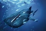
The biggest fish in the world - not blue whale as one might think, because the whale belongs to a ma
Before it was invented fridge, its functions were performed in the ice, which was considered a preci


Предлагаем восстановить, заказать, купить диплом Вуза в любом городе России. Только настоящий бланк ГОЗНАК с гарантией.
All rights reserved