Viewings: 12242

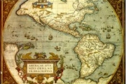
The image of America on the map Piri Flight is one of the few preserved till our days. Historians have found it in 1929 in the pile of rubble at the Topkapi Palace in Istanbul. Today, the map is stored in the library of the Palace, and very rarely exhibited for public viewing. Map Dating from 1513, was painted on the skin of a Gazelle Turkish Admiral of the fleet of the Ottoman Empire the Piri Reis.
The map shows a grid of crossing lines - the so-called "loxodrom"that were used for laying rate and were characteristic of the medieval sea cards. Careful examination showed that it was originally a map of the world, which is then ripped apart.
Map of sailing directions on how today he would be called, was a typical document of the XIV - XVI centuries, These maps have been created for seafarers, floating from port to port. They were not suited for long-distance ocean travel, as it does not take into account the sphericity of the Earth. Undoubtedly, the ancient image of America is of great interest to historians, and not only. In his book "Maps of the kings of ancient seas", released in 1966, historian and geographer of the University of new Hampshire Charles Hapgood suggested that the area of land at the bottom of the map to the South of South America clearly indicates the Antarctic (and this is well before the continent was opened!). On the map drawn in detail the coastline of Antarctica and presents, according to Hapgood, the exact image of the Queen Maud Land without glaciers. In his opinion, this testifies to the fact that it was mapped in prehistoric times, before the continent has held down the ice. But how stone age man could see, and to map Antarctica? Hapgood believed that once existed forgotten today prehistoric civilization, people traveled in the oceanic expanse. They sailed from pole to pole, so even in the past were able to map the entire surface of the Earth. According to the theory Hapgood, these civilizations have left us a legacy card over a thousand years old. Their copies enjoyed seafarers crops such as the Minoan and Phoenician. To such ancient maps Hapgood attributed and map Piri Flight.
Later Erich von d?niken argued that depicted on the map Piri Flight Antarctica without ice cover confirms his theory of ancient astronauts, and said that its first version was created by representatives of extraterrestrial civilizations. In his book "Traces of the gods", written in 1995, Graham Hancock also pointed out that in the past there was now unknown, highly developed ancient civilization. Their profound knowledge in astronomy, architecture, navigation and mathematics moved drevnim cultures of the Olmec, Aztecs, Mayans and Egyptians. He also said that the creators of the map Piri Flight used as sources of copies of the ancient sorceleur. And Hapgood, and Hancock noted that represented on the map Piri Flight image of Antarctica performed extremely detail: it contains mountains, rivers and lakes. When creating a basis could be taken ancient satellite observation that is over Egypt.
Many scientists and archaeologists skeptical of the theory Hapgood. Mainly because there is no source, evidence of the existence of ancient civilization, which would have the resources, technology and especially the need to explore Antarctica. What could be the reasons? Even assuming that such a highly developed prehistoric culture existed, the question remains whether on the map Piri of as depicted Antarctica without ice cover? Most supporters of the theory of the ancient civilizations of the sea complain about lost geographical knowledge, the existence of which confirms the accuracy with which the card, especially in depicting Antarctica. However, so does the exact map Piri Flight? The absence of the Drake passage between South America and Antarctica indicates that if the card is really depicted the South American continent, it is connected with the Antarctic land mass of almost 932 miles. And this blatant error for that specific card.
Studying the remaining part of the map, which shows Europe and Africa, you can see a very detailed for that time of the image. However, the size of bays and peninsulas increased, that, apparently, is connected with the navigation of the time, which was made on coastal targets. South America seems to be too narrow, while Brazil shows quite okno. At the same time, North America shows unclear and very casually, as if drawn with the words, and not on the basis nogayskih knowledge. These data allow to assert, that in ancient times was not conducted extensive research, based on which it would be possible to create an accurate map. With should be noted that there are ancient maps, made more carefully than the card Piri Flight. So, on the map 1500 Juan de La Spit and Alberto Cantina more precisely shows the position of the Islands of Cuba, Jamaica and Puerto Rico. The only part that can serve as a confirmation of the authenticity of the card Piri Reis, is that it allegedly showed Greenland to glaciation. However, even a cursory examination in the upper right corner of the map distinguishable Western part of France, located on 50 North latitude. Therefore, if France are presented on the map as the most Northern country, Greenland, it should not be, and because there are no Islands that even remotely resembled Greenland, it is very difficult to say whether these data evidence that version.
To confirm the theory that at the map Piri Flight depicted Antarctica without ice, Charles Hapgood, used data from acoustic studies, received during the Antarctic expeditions of 40-50-ies of XX century, However, the hypothesis Hapgood that once seemed scientists quite probable, today raised serious doubts. Appeared insurmountable contradiction relating to the frozen Antarctic drawn on the map of Pirinaca. After the mainland has finally thawed, its coastline had to change. She could not meet the modern shape of Antarctica. Over time, the earth's crust of the continent was to fall on hundreds of meters under the weight of the underlying million tons of ice and below it, the coastline is a total change. If you compare the Antarctica on the map Piri Flight with the relatively recent topographic map subglacial surface of the continent, it is clear that between their coastlines have nothing in common. In addition, modern geographical research suggests that Antarctica is free of ice is not in 4000 BC, according to Hapgood. Recent data on the period of existence of unfrozen Antarctica show that it was more than 14 million years ago.
But, perhaps even more compelling evidence refuting the prehistoric origin card, contained in the notes by the Piri Flight. In the early sixteenth century, when he drew his card, the Portuguese had already made the trip across the Atlantic. They mentioned the open them part of South America. In the text of one of the labels on the map refers to attack the indigenous population of the Portuguese ship, adhering to the coast of the southern continent. In the other labels we are talking about the incredible heat. This data is appropriate for the description of South America. But the weather is hot and naked residents in Antarctica is just a fiction.
Don't know which sources you used to create the maps Piri Reis, however, it can be assumed that among them were the works of the Greek astronomer and geographer Ptolemy (II century ad), various Portuguese map and map of Christopher Columbus. It should be noted that the Flight itself acknowledged that the copied map of Columbus. In addition, many features of the card Piri Reis, in particular geographic name and image elements of the West Indies, saying that he had used at least one card of Columbus to create your own. Another indication that the Flight was using maps of medieval Europe, is depicted in the upper part of the ship and the fish that lays on his back two people. Under the picture was a quote from ( srednevekovogo stories about the life of an Irish Saint Bran-yuna. Apparently, Piri Reis moved it to one of the card source. This fact proves that has been used at least one card of medieval Europe.
Greg Mackintosh in 2000 in the book "Map Piri Flight 1513," notes that if to look at the maps of the time, it becomes clear that on the map Piri Flight there's not anything that would not be known in 1513, He also argues that lands on the map Piri Reis, who consider Antarctica, in fact, are hypothetical Great southern continent which cartographers were mapped from the time of Ptolemy. It was considered that in the southern hemisphere must be a continent to keep the balance mass of the Earth in contrast to the Northern hemisphere. Mac also noted that on the map Piri Flight all coast, located South of 25 degrees, inaccurate and are not in their places, and Antarctica in the North reaches 40 degrees South latitude, although in reality it never went over 70 degrees. Careful examination of the card Piri Flight shows that it most likely is not depicted Antarctica. Because bears the southern continent is very similar to the American, perhaps on the map drawn part of South America, adjusted in size to the form of parchment.
Another feature of South America on the map Piri Flight is the imagethe terms of ranges of the Andes and the rivers of the Amazon, Orinoco, and La Plata, which starts on the slopes of the mountains and flowing on the East, to the sea. In those days, the Europeans did not know about the Andes, how they ended up on the map? However, the Piri Reis map not only shows mountain ridges deep in the South American continent. Map Nikolo de Canario (1502-1504 years.), which is now kept at the Paris National library also contains the image of the East coast of South America with the tops of mountain ranges. These data suggest that, most likely, map of Kaneria was another source for Piri Flight. It is still unclear another question. If the map Piri Flight based on information ancient navigators, there could be drawn in the Andes, but the Pacific is unlikely. A more reasonable explanation is that the mountains, is depicted in the centre of South America on the map Piri Reis, in fact located on the Eastern coast of the continent, but drawn in the wrong place and not at the scale.
Most scientists today believe that the card Piri Flight more accurate than would be expected from the medieval navigation maps of the XVI century, which was based PA geographical knowledge and assumptions of those times. There is no reason to believe that Piri Reis relied when you create your map to work any hypothetical superculture. Of course, he could use ancient sources, which have not survived to the present, but the card itself is of great value as beautiful and important source of the middle ages.
B. Haughton


