Viewings: 6176

To open a new land, but the "close" it, i.e. to prove that that does not exist is more complicated. Recently, however, scientists from Australia managed to do it. A group of researchers has been able to prove that sandy island in the coral sea, although he noted on many maps, is actually a product of the imagination of cartographers.
As we know, the term "to open a strange land" implies not only the fact of arrival of the traveller on this territory and drawing up a detailed map. The latter should be such that it needed will be able to take advantage of other people, that is composed of all existing rules cartography. If there is such, and is determined by pioneer. For example, the discovery of Australia is traditionally attributed Dutch Navigator Abel the Tasman, and not unknown Portuguese travelers who have visited on this continent before him. And all because Tasman made a map of the Green continent, but the Portuguese - no.
Well, in that case, you can ' close" any area? Very simple - to visit there and prove that in reality it does not exist (again with the help of drawing up detailed maps). Although "geographically close" happen much less often than the opening (the most famous example is "close" in the nineteenth century the mythical land of Sannikov), but they also happen from time to time. Even in our days, when the seemingly system of satellite photography was once and for all do away with white spots on the maps.
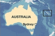
Not so long ago there was another similar solemn "geographically close" - a group of scientists led by geologist Mary Seton from Sydney University have managed to prove that one of the Islands Coral sea, is marked on many maps, is actually a figment of the imagination of geographers. We are talking about the island sandy (which in Russian means "sandy"), which, according to the cards were near the archipelago of New Caledonia, and therefore, according to all laws, was part of the overseas possessions of France. A team of researchers who studied the tectonics of lithospheric plates, decided to visit this island, which has long walked strange rumors.
The matter is that despite the fact that sandy is already 12 years old was involved in a highly reliable databases coast lines, before the journey, scientists have not been able to find any images of this piece of land, nor any clear descriptions of the island. The impression was that there never was - and this despite the fact that modern tourists-a mixture of Green continent tend to visit any tiny island in very attractive for recreation coral sea, which is located away from the busy trade routes.
Moreover, as one participant says expedition, Steven Micklethwait from the University of Western Australia, on those maps used by the crew of the vessel, carrying scientists, sandy, too, was absent. However, when the researchers told about it to the captain, he remembered that he had reported on the Islands in the area, but he himself never seen him. And since, according to the testimony of GPS-Navigator, sandy was located not far from the place of study, at a meeting of the whole expedition was decided to look to him, "you" relax after work and be finally a detailed description of this piece of land.
Interestingly, when the ship headed straight to sandy, the captain of the vessel RV Southern Surveyor is very nervous, fearing to land the ship aground (for about Coral sea Islands such are not uncommon). However, his trouble was in vain. According to the memoirs of Dr. Micklethwaite: "...in the place where he was to be the island bottom has not even been raised from the edge of the wave until it was at least 1 300 meters. We have not seen sand, neither palm nor turtles. Everywhere was one blue water. This island was a mistake once surveyors or cartographers".
As you can see, the scientists not only could not put on many maps of the island, but still researching this area, proved that there never was. Surveys of the seabed showed that no reefs, which could hit the ground, in this area there is, the bottom was completely smooth. Failed geologists found traces of seismic and volcanic activity, which could in principle fast enough to destroy the island.
Why then sandy for a long time existed in databases coastlines, though actually this island was not? It is not excluded that geographers could assume the existence of the island, based on indirect data - for example, on anomalous behavior of sea currents. Or the island appeared because of incorrect decoding satellite image - it also happens quite often. Significantly, however, is that information about the existence of a new piece of land for 12 years, no one bothered to check. But in the epoch of the Great geographical discoveries travelers would have done it over the next few years or even months! Alas, their modern descendants were much more lazy and less curious.
Commenting on this amusing incident, President of the British cartographic society Danny Dorling said that should not be so hard to judge modern geographers. Ideal cards humanity has not had never will be, especially when you consider that all of today's card is a "grab-bag" of high-precision satellite images and historic data collected during his travels more than a century ago. It should also be noted that the coral sea is located away from the busy sea routes, so in a immediate verification of the received data was not interested no office (while in the previous era that many were willing to pay the costs of such expedition - then all were interested in the development of new land).
At the same time, Mr. Darling noticed that it will not be too surprised if this island really exist, but with different coordinates. According to him, it is high time to restore order with maps some remote regions of the earth. However, perhaps some of the earth will not be where it is considered, while others, like sandy, will sink into oblivion. According to Danny Dorling, now, in connection with the development of technology, a new era of "the Great geographical closings", during which will be finally put in order in cartography.


