Viewings: 7330

The ancient mysteries always attract modern man. Look, as if through a window into the mysteries hidden time civilizations help us maps of our world... we never knew.
Not inferior to modern
To create an exact geographic maps necessary vessel, capable of distant sail for site investigations, chronometer to determine the coordinates, as well as mathematics and cartographers for processing received information.
Meanwhile, there are ancient maps drawn BC that accuracy is not inferior to modern, while on the research vessels (according to the official story) was not the question, and the same chronometer was invented by the English clockmaker John Harrison only in 1761. What has been used by ancient cartographers? Surely they had reliable vehicles and not less accurate devices, if to take into account the fact that sometimes their cards even surpassed in the reliability of modern analogues.
Unfortunately, this ancient originals not come down to us intact. They are many times redrew, transferred from one material to another. Mankind has tried to preserve found once knowledge of the world, it may be transferred to an unknown powerful civilization.
Map Piri Flight
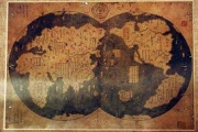
On the margins of the map Piri Flight written: "None currently do not have a map like this. Making it, I used the twenty nautical charts and eight"MAPP mundis", i.e. cards, called by the Arabs "galeriyi" and composed during the time of Alexander the Great, which depicts the entire inhabited world."
This map was drawn up in 1513 Turkish Admiral Piri Reis, she became part of his Atlas of the "Kitab-I-bahra" ("Book of the seas"). After almost 200 years of surviving satin sheets were published in Europe, but did not arouse any interest. Only in 1956, when the map came to the U.S. military cartographers, began its systematic study, gave us a few sensations.
A sensation number one
On the map depicts the Americas. Nothing surprising at first glance, because the card was completed after the voyage of Columbus. However, Columbus did not make such careful cartographic description of the terrain, and his expedition did not go into the continent, so he could not display Delta American rivers, and especially the Andes!
Look what he writes about Christopher Columbus himself Piri Reis: "Invalid by the name of Colombo, the Genoese, opened these lands. In hands of the mentioned Colombo got one book, in which he read that on the edge of the Western sea, far to the West, there is the shore and the island. There they found all kinds of metals and precious stones. The above Colombo long studied this book... About the passion of the natives to glass ornaments Colombo also learned from this book and took them to be exchanged for gold. It turns out that Columbus was a book, and a map, which he followed in swimming. We can assume that Christopher Columbus, married the daughter of the former master of the knights Templar, and received from him an ancient book and map of America, have become landmarks in his journey. Know where you float is the key to success in the era of Great geographical discoveries!
Here we are more important conclusion - map of Columbus and maps Piri Flight have the same ancient source! And how it's so old, will tell us next sensation.
Sensation number two
On the map Piri Flight shows the coastline of Antarctica, and drawn with high accuracy! The findings of modern scholars suggest that Antarctica this map shows even before the complete glaciation (about 6000 years ago!).
Here is a report of the American cartographers: "the claim that the lower part of the map shows the Coast of the Princess Martha, part of the Queen Maud Land in the Antarctic, as well as the Peninsula Fell-a measure that has a Foundation. We found this explanation is the most logical and possibly correct. Geographical details, the depicted in the lower part of the map, perfectly coordinated with the data of seismic survey, performed through the thickness of the ice caps of the Swedish-British Antarctic expedition in 1949. This means that the coastline was marked on the map before she was covered with ice. The ice on this territory has a thickness of about 1.5 km. we Have no guesses how these data could be obtained at the expected level of geographical knowledge 1513".
And now comparable: the glaciation of Antarctica occurred at a time when melted glaciers America and Europe. I.e. we see before us the picture of the ancient antediluvian world! (Referring to the flood 9612 years before our era, associated, in the opinion of some scientists, the deviation of the earth's axis.)
But if we deal with such a perfect ancient source, the question remains: who and when was it created? Maybe that will help us to understand this other ancient maps?
Mercator Map
Gerard van Kremer (known as the Mercator), a Flemish cartographer and scientist, has ended his Atlas, which included several of his own cards, in 1569. We are interested again Antarctica map, where is perfectly viewed the Amundsen sea, the Cape of Gerlicher and Cape Dart at the Marie Byrd Land, island of tarstone, the island of Alexander I, the Weddell sea, the island PADD, ridge Regula and other geographical objects is marked on modern maps.
We are certainly interested in the past. It is in a small sub-polar zone, the rest of the territory carefully drawn: rivers, valleys, mountain ranges...
But this map is not the last in this chain...
Map Of Philip Boise
A map published in 1737-almost a hundred years before Antarctic expedition of bellinsgausen and Lazarev. Just amazing the fact that the map was created before the start of glaciation of the continent! It East and West Antarctica are separated by a Strait, passing through Transantarctic mountains, which can be detected only in the complete absence of glaciers!
So, the source of the card Base is even more ancient than the card Piri Flight and Mercator!
Hypothesis: where we have these artifacts?
The Americans made a great contribution to the study of ancient maps. Historian, geographer, Professor Charles Hapgood compared coastline of Antarctica on all available ancient artifacts. In his book "marine Maps of kings" he wrote: "This is the first convincing evidence that some quite intelligent people was preceded by all Nations, known history... Ancient travellers plied the seas from pole to pole. As it is surprising, there is undeniable evidence that the ancient people had explored the coast of Antarctica, while they were still free of ice. No doubt also that they had other navigational instruments, which surpassed all those that were available to people in the Ancient world, middle Ages and up until the second half of the XVIII century".
American scientists after the great Patriotic war was a map projection center in Cairo (where the U.S. military base), compared it with the old card Piri Flight and found almost full similarity. Therefore, it is logical to assume that the center of the projection of the map source Piri Flight was near Cairo. Goes, ancient cartographers were Egyptians or their ancestors?
But as the ancient Egyptians may know the basics of spherical trigonometry and almost without error to determine the exact length of the equator? (Aristofan, added in ancient times the circumference of the Earth, and did it with great accuracy, invalid when creating such a precise maps!)
Hapgood argues that the Central projection of an ancient map Piri Flight passes through Alexandria, where the famous library could be preserved its original source. What, strictly speaking, it was, there is another guess.
Referring to some studies, it can be assumed that the ancient cartographers - kings of Gahramanov that ruled at that time in Egypt. Plato calls them still kings of Atlantis! Remember that the incomprehensible knowledge, according to legend, possessed of Atlanta. And it is possible that this knowledge they used and to create maps.
Just imagine this mighty civilization with telepathy, control aircraft and are able to create artificial satellite of the Earth! They could very carefully study our planet from space, and then process the information is still not available to mankind ways. It is unclear then only, for what paid for these supermen? Anyway, I want to believe that they left us with ancient heritage, and therefore, humanity still has a chance to reach their heights in the field of science and progress. The main thing is not to repeat their mistakes...


