
|
Viewings: 6709
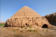
 "In a sepulchral silence we got up on the plateau, leading the horses by the reins. Awful view opened our eyes. The stone was not the end. We went exactly huge abandoned home and held her horses, trying not to knock "on the floor". Nothing living around: neither bird nor nomads, not a single blade. If I was told that there is such a country, I'd never believe that..." "In a sepulchral silence we got up on the plateau, leading the horses by the reins. Awful view opened our eyes. The stone was not the end. We went exactly huge abandoned home and held her horses, trying not to knock "on the floor". Nothing living around: neither bird nor nomads, not a single blade. If I was told that there is such a country, I'd never believe that..."These lines written on the Mangyshlak Peninsula, located on the Eastern shore of the Caspian sea. And they are not written a thousand, not five hundred, and not even a hundred years ago. Wrote them in 1933 Commissioner one of the red army troops. Once, years ago, at the place of the local stony deserts was flowing river, the grounds were covered with thick grasses, grazed herds of wild ungulates, under the shade of broad-leaved trees hid predators - tigers, lions, cheetahs. But gradually the climate was changing, becoming more and more arid. Sands, jamming sand ridges, won the blossoming steppe. Despite the harsh climate huge anhydrous, sun-scorched earth Mangyshlak has long enticed not only geologists, but travelers, researchers, lovers of adventure. On Mangyshlak is mentioned in Strabo and istakhri. The Khazars and the Seljuks, Mongols and Khorezmians were accumulating water in rare desert wells. In the spring of 1715 from well to well was Cossack detachment of the captain of the guard Bekovich-Cherkassky. The captain went to the TRANS-Caspian region by the order of Peter the Great to learn where the "dead Uzboy river and whether judges can be revived. The Bekovich returned to St. Petersburg after six months, losing half of his people. He talked about the evil Sands, about solitude, the wells, the water in which the "small is excellent from the sea, and sand from the sea potolya, and the stench was overwhelming", about heat and diseases. Peter listened to the captain and ordered to go back. With two thousand squad captain came out of the Guriev towards Khiva - in his last tragically torn expedition. He went in search of Yarkand to take the "arm" of the Russian Tsar rich "Pesochny gold" of the neighbourhood. He knew that to the "Golden town" need to go for the Syrdarya river in the upper reaches of its main tributary, crossing the whole Kyrgyzstan violent and non-navigable Naryn. People sent in advance for exploration, brought him a map of the route from the Caspian sea to Namangan... Gold was not the only and not the main task of the expedition. Peter instructed to Prince Alexander Bekovich-Cherkassky to establish diplomatic relations with Khiva and Bukhara khans, in order to implement one of the most grandiose plans of the era to create a single water way from St.Petersburg to India along the Volga, the Caspian sea, the Amu Darya and Panj. For execution of this" Prince was ordered to block the dam of the Amu-Darya river and turn to the West discovered by Russian pioneers "old channel". Otherwise - to restore the flow of Uzboy, once connected the Caspian sea and the Amu Darya. Peter's plan was ambitious, but hardly feasible. To carry out the project and in our days, is hard work. Prince Bekovich-Cherkassky, however, did not have to turn back the river. Shir Khan-Gases, who ruled Khiva, had been cajoled squad in the trap - he decided not to allow the "infidels" in Asia. Khan kissed the Koran and swore in friendship, while his henchmen had already prepared the massacre, pulling to Khiva twenty-five thousand strong army. Russian soldiers and Cossacks were disarmed one bound, and carried off into captivity, other on site chopped by sabres. The commander took a painful death: "... was taken out of the tent Mr. Prince Cherkassky, and dress all removed from it, has left in his shirt, and standing cut by sword and cut off his head..." MYSTERIOUS PICTURES Day in the desert reigns heat. If anyone dares to go there without water, he won't have chance to lay back. The hot wind and the sun will bleach and Polish to Shine bones unlucky for us to new travellers saw the fate of his predecessor. No wonder so common here the name tracts "Barsakelmes", which means: "Go - no return." In our days the Mangyshlak he also started to learn from the air. In October 1986, Russian scientists examined the monuments of medieval architecture on the Ustyurt plateau. Flying by helicopter between SAI-Utes and Beineu, they suddenly saw that the vast area covered with some pictures. There were many of them, each with a diameter of hundreds of meters. Furrow, passing from picture to picture, were drawn spiral of different forms: accompanie or trehlistna, reminiscent of a dragonfly or the wings of birds, ideal ellipses and circles. From the earth, these spirals not guessed as something solid, so their first no one noticed. At first it seemed that the drawings made recently. However, soil scientists, who studied the area, said the age of the spirals can be traced back hundreds of years, as the soils here are porous, retains traces. Opinions archaeologists have dispersed. Some believe that the pictures are very old, probably Dating back to the Neolithic era, others - later. A few kilometers West of the plateau with drawings are the remains of an unusual settlements, surrounded by two defensive ramparts. Outside is a palisade of approximately 10 m in width, made of stones with a pointed top. The most interesting thing is the design of the monument. Its unique shape, resembling an altar, as well as spiral drawings, has no analogues. Maybe there is some connection... When, by whom and with what purpose were created great drawings on the Ustyurt plateau, remains a mystery, but looks very tempting parallel with pictures of the desert Nazca in Peru. THE UNDERGROUND CHURCH Many years on Mangyshlak and Ustyurt worked Paleolithic squad Mangyshlak expedition of the Academy of Sciences of Kazakhstan. Scientists have discovered more than a thousand monuments of medieval architecture: ground and underground temples, huge city of the dead - necropolis. In different parts of the Peninsula are open and underground spaces carved into solid rock. As a rule, they are small. This monastery and tombs of Muslim hermits. Especially interesting unusual scale and complexity of the underground structure of the IX-X centuries, located near the southern coast of the Caspian Bay Sarytash, - underground temple of Shahbagota. The entrance was decorated with figures of animals, mysterious logo, ornaments and Arabic inscriptions-epitaphs. The location of figures of animals, labels, and other elements are strictly thoughtful composition. The left and right of the portal - the burial niche. On the wall of one of them placed a large engraving - battle horse archers. In the corners of the Central hall, cut down under the ground, stand four columns with capitals. Their height is more than two meters, and the capitals of four different and original types. The vault of the Central hall - domed, with a round hole sun rays in the centre. THE DEPRESSION MADE BY THE WIND From the height of land Mangyshlak reminds waterto camel skin: grey-yellow with brown tufts of dry grass. Sometimes it is lifted, as if twisting low ridges with white chalk sides. And again - the flat earth, rugged the channels of dry rivers. On the West coast of Mangyshlak, in the foothills of Karatau, is the Karagiye depression. It has a length of about 50 km, a width of 30 km, the bottom of the basin is below the World ocean level by 132 m and 100 m below the waves of the Caspian sea. Its origin is mysterious, not to be explained by any known geological processes. When the basin is formed by the slow lowering of the earth's crust, the rock formations, curving, take in the cut-section plates. If she grew due to the earthquake, then at the bottom it be breed more young than on the sides. But nothing of the kind in Karaginsky depression is not. Layers and at the bottom, and the edges are completely broken. The impression is like a bucket of some giant excavator just took and took out a piece of the earth's crust, and then drowned her in the sea, and there was no trace left... lately geologists launched a new version of the origin of the Karagiye depression. It "blew out" wind couple of million years ago. 15 thousand billion cubic metres of land have vanished dust around the world! The best explanation is not found yet.
You are reading news Подземные храмы Мангышлака
if You liked the article Подземные храмы Мангышлака,
prokomentiruet her.
|

The world of the unknown - Onua.org
Onua.org - this site created to familiarize the user with the world of the unknown, news of technology, space discoveries and mysteries of the Earth UFO, Video , Photo, the Witnesses, the mysteries of history and ancient civilizations.


Menu
- Anomalies
- Hypothesis
- The Mysteries Of History
- Unknown
- News
- Opening
- Top secret
- Prophets
- Ancient civilizations
- Egypt
- Rome
- Greece
- Anunaki
- Nazca
- Maya
- Cosmos
- Technology
- Flora and Fauna
- Atlantis
- Bermuda triangle
- Aliens and UFOs
- Cloning
- Loch Ness
- Mysticism and Magic
- Time machine
- Parallel world
- The Tunguska meteorite
- Third Reich
- Teleportation
- Snow man
- 2012
- Nibiru
- Solar system
- The sun
- Earth
- Mars
- The rest of the planet
- Photo
- Video
- A little about everything
- Украинские аномалии
- 2013-2014 YEAR
- Questions and answers
- 100 great
Interesting
Recent VIDEOS
News calendar
Join
Popular Onua.org
Photo

The biggest fish in the world - not blue whale as one might think, because the whale belongs to a ma
Before it was invented fridge, its functions were performed in the ice, which was considered a preci


Предлагаем восстановить, заказать, купить диплом Вуза в любом городе России. Только настоящий бланк ГОЗНАК с гарантией.
All rights reserved